• Beautiful Lake Maninjau : West Sumatra Destination

    Lake Maninjau is a volcanic lake that is located at 461,50 meter above the sea level. Its width is 99, 5 km2 with 4, 95 meter of the maximum depth. The existence of Lake Maninjau has created a folktale called "Single Sembilan" (The nine Bachelors). People living around the lake believe that those nine Bachelors are real...

  • Bantimurung Waterfall the Best Destination in South Sulawesi

    Bantimurung waterfall (15 meters in height and 20 meters wide) is a very famous natural tourism destination in South Sulawesi. Pure water falls down from the crag every year. Beneath the waterfall, there is a bathing place made of limestone covered by mineral vein which is caused by the stream flow for hundred years....

  • Nimanga River, Best Rafting in North Sulawesi

    Nimanga River is one of the most favorite tourism destinations in the North Sulawesi. It has been popular as it is used for any kind of extreme sports and other activities. It will be great experience for having an extreme sport such as rafting along the river...

Wednesday, March 21, 2001

The History of Museum of Lambung Mangkurat in Banjarbaru South Kalimantan

    The History of Museum of Lambung Mangkurat in Banjarbaru South Kalimantan
    Museum of Lambung Mangkurat

    The Museum of Lambung Mangkurat was officially opened in 1979. It is traditional house of Banjar architecture, Rumah Bubungan Tinggi(High Ridge House), which is polished in modern style. The collections of the museum are the archaeological remains of The Sultanate of Banjar, Agung Temple, and Laras, stone alliances, Ulin woodcarvings, farming tools and household appliances, and traditional music instruments.
    The Museum of Lambung Mangkurat, is a two-storey building. The first floor has three display rooms; an open exhibition room and two close exhibition rooms. In the open exhibition room, visitors can find three river transportations mean of Banjar people: jukung sudur, perahu pandan liris, and jukung tambangan. Beside those three kinds of boat, visitors will also find kinds of sea fauna fossil, such as whale (Rhineodon Typus Cotaceae) skeleton. While in the close exhibition rooms, visitors will be brought to the age far before we were born. In one of the rooms, visitors can see the displays of devices used in the pre-history age, such as pickaxe, shoulder axe, pahat kapak lonjong, and bronze axe mould. In the other one, visitors can find kinds of archaeological remains of Banjar kingdom.
    In the second floor, visitors can observe some ethnical photos painting and the map of the dissemination of Indonesia tribes in South Kalimantan. In this place, visitors will find some types of traditional Banjar house such as Bubungan Tinggi and Gajah Manyusu. Moreover, visitors can also find the life cycle diagram of Banjar people, from birth- children- adults- getting married- giving birth- phase, until death. Those phases are described in some Islamic ceremonies such as Baayun Anak, Basunat, Baantar Jujuran, Batamat Al Quran, andBakawinan.

    Entering the Museum of Lambung Mangkurat, visitors are brought to experience the era when South Kalimantan had not became a province yet. This Museum give a better understanding to the visitors about the development of Banjar people from the stone age, when all devices were made of stones, until the age of the influential kingdoms that existed in South Kalimantan. Seeing Genta Kencana (a place where the king rested), for example, the visitors will know the civilization of Banjar people at the time.

    How to Access Location Museum of Lambung Mangkurat?

    The Museum of Lambung Mangkurat is located in BanjarbaruBanjarmasin city, South Kalimantan province.  The Museum of Lambung Mangkurat is located in Banjarbaru, 35 km from Banjarmasin. The strategic location on A.Yani Street, makes it easy to reach by any public transportation or private transportations. From Syamsudin Noor Airport Landasan Ulin Banjarbaru, it takes about 20 minutes. 

Tuesday, March 20, 2001

Mount Bromo

Mount Bromo
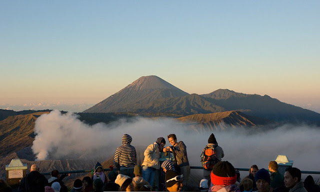
Mount Bromo Sunset

The word bromo is derived from ancient Javanese language brahma, the name of a Hindu deity. According to Tengger (the original tribe inhabiting Mount Bromo) people, Mount Bromo is a holy mount, so it requires an annual ceremony called Yadnya Kasada or Kasado. It is a local ritual of throwing natural wealth into the crater of the mount. The ceremony is held at midnight in a full moon of the tenth month of Javanese calendar. By such ritual, Tengger people ask for an abundant harvest and hope for being avoided from disaster and recuperation from ilness.

Mount Bromo, which is known still active, includes into the area of Bromo Tengger Semeru National Park. It was officially opened by Indonesian government in 1997. It is a 5.250 ha wide of sandy area located at an altitude of 2.000 meters.

Mount Bromo


This 2.392 meters above the sea level mount is famous for its wide sandy area and large crater. Taking a bird`s eye view from the top of the mount, you will see the large crater bleaching out thick smoke from the bottom. The crater is 800 meters in diameter (north to south) and 600 meters in diameter (east to west). From the same place, you will see the panoramic view of sandy area with naturally splendid silhouette of the surrounding places.

Watching the sunrise from the peak of the mount, hanging around the location by riding horse and tasting a glass of local beverages while having a bonfire against the cold weather are some alternative activities for you visiting the destination. Besides of natural tourism that will be experienced, you will be familiar with cultural tourism atmosphere, especially when the ceremony of Yadnya Kasada is held. In addition, for you who want to watch the ceremony of Yadnya Kasada, you better come to Mount Bromo during December to January.

Mount Bromo


Mount Bromo Location

Mount Bromo lies in four different districts: Pasuruan, Probolinggo, Lumajang, and Malang. All are in East Java Province. However, administratively, it is located in the district of Probolinggo. You can access Mount Bromo by using either public transportation or private car. To reach the location, you can acceess via “the western gateway” from Pasuruan District. However, accessing the location via the western gateway will be hard as it can only be accessed using jeep car. In general, most of visitors tend to reach the mount by walking from Wonokirti Village for about 13 km away.

Accessing the mount via “the northern gateway” from Probolinggo District. Via this way, you may use any public transportation remembering the access to the location is not too steep. If you want to watch the sandy area of Mount Bromo, it is better for you to pass by this way. Otherwise, if you want to watch the sunrise, just take the trip through the western gateway.

The nearest village to the mount is Cemorolawang Village around 45 km away from Probolinggo District. It can be reached by public transports from Probolinggo. In addition, to reach the mount from Cemorolawang Village, you had better charter a horse or jeep car and you may walk as well.

Bonfire provided by some food tents can be alternatives for you against the cold weather in the location while tasting lukewarm beverages. When you need to spend more days there, you can easily find lodgement, shelter and hotel around the destination. Multifarious restaurants, souvenir shops can also be found there proposed to offer comfortable visit for you.