• Beautiful Lake Maninjau : West Sumatra Destination

    Lake Maninjau is a volcanic lake that is located at 461,50 meter above the sea level. Its width is 99, 5 km2 with 4, 95 meter of the maximum depth. The existence of Lake Maninjau has created a folktale called "Single Sembilan" (The nine Bachelors). People living around the lake believe that those nine Bachelors are real...

  • Bantimurung Waterfall the Best Destination in South Sulawesi

    Bantimurung waterfall (15 meters in height and 20 meters wide) is a very famous natural tourism destination in South Sulawesi. Pure water falls down from the crag every year. Beneath the waterfall, there is a bathing place made of limestone covered by mineral vein which is caused by the stream flow for hundred years....

  • Nimanga River, Best Rafting in North Sulawesi

    Nimanga River is one of the most favorite tourism destinations in the North Sulawesi. It has been popular as it is used for any kind of extreme sports and other activities. It will be great experience for having an extreme sport such as rafting along the river...

Friday, December 23, 2005

Penyengat Island

Penyengat Island

During the golden era of Riau-Lingga Sultanate, Penyengat Island held significant roles in governmental and educational sectors. The island was likewise the heart of Islamic teaching and Malay cultural civilization in the past. For that reason, the provincial government of Riau Islands fixed the island as the highly recommended historical tourism destination. The remaining traces of Riau-Lingga Sultanate can still be found in the island, even though some of them are in critically physical condition.

Once upon a time, there were some fishermen and pirates anchored off the coast of the island. They came to the island for pure water that was hard to find in other places except in Penyengat Island. Feeling of being disturbed by those people, a group of bee flied over them to take revenge on. Those people got stung by the bee, so the island was named “Penyengat” that literally means “stinger.”

Another story grappling with the early history of Penyengat Island is the story of Sultan Mahmud Marhum Besar, who ruled over Riau-Lingga Sultanate from 1761 A.D. to 1812 A.D. It is said that the sultan proposed a marriage to Engku Putri Raja Hamidah, the daughter of Raja Ali Haji. As he loved the girl very much, a 240-ha island named Penyengat was bestowed upon her by the Sultan.

Start historical travelling in Penyengat Island by taking a visit to the Great Masjid of Sultan Riau. The masjid was built in 1832 A.D. upon initiative by Yang Dipertuan Muda VII Raja Abdul Rahman. The masjid keeps some handwritten Korans and a number of ancient manuscripts that were written on Arabic and Jawi scripts.

Penyengat Island

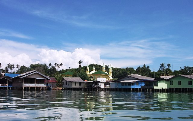
The architecture style combines the Malay, Arab, and India styles together. It is said that the masjid‘s wall was the mixture of red-bricks and albumin, which was used as the glue.

Feeling enough observing the elegance of the Great Masjid of Sultan Riau, you can move to other historical sites but, we recommend you to take a visit to several mausoleums of Riau-Lingga Sultanate staffers. There you can find the mausoleum of Engku Putri Raja Hamidah and Raja Ali Haji‘s graveyard. The most interesting one is the mausoleum of Raja Ali Haji because here, you can see one of his great literary works entitled Gurindam 12. You can read the whole series of Gurindam 12 that were carved out on the mausoleum‘s wall.

Move to another site, thus you will find an adat house where numerous royal properties of Riau-Lingga Sultanate are kept well within. In this Malay-style building, the Riau Islands people often hold some activities such as adat meetings and wedding parties. Moreover, the local inhabitants usually take some water from a spring located on the ground floor of the building. They do believe in the efficacies of the water, which can heal certain diseases. By the way, the water is believed to have ability of helping the one for getting a marriage partner soon.

Bukit Kursi Fortress, which was built during 1782 to 1784 A.D. when the Riau-Lingga Sultanate was under the role of Raja Ali Haji, is another must-be-visited site. The fortress was built facing directly to the sea, hence you can experience two travelling sensations at the same time, undergoing historical travelling and enjoying the turquoise sea water.

Penyengat Island Location

Penyengat Island is part of Riau Islands Province that includes administratively into Tanjungpinang Sub-district. To reach Penyengat Island, you can take water transportation called pompong from Sri Bintan Pura Port in Tanjungpinang City. It is hard to find any hotels and inns in the island. You can only spend the night at the local people‘s houses here. Likewise, public transportation such as busses and taxis is really hard to find. The best way to look around the island is taking benmor (motorized pedicab) with IDR 20.000/hour for its cost.

Wednesday, December 14, 2005

Shopping Center Book Market

Shopping Center Book Market

Your trip to Yogyakarta would be incomplete without visiting Yogyakarta book market that is better known as the “Shopping Center”. On Sriwedari Street, lines of kiosks displaying various books will be seen right away. Its existence as a book shopping center cannot be separated from the status of Yogyakarta as the city of education, in which tens or hundreds of state and private universities lie. Yogyakarta has become a melting pot of students coming from different areas of Indonesia and even Southeast Asia. The survival of the Shopping Center has of course been owing to the high reading tradition of Yogyakarta citizens.

“Book is the Window of the World”. Occupying a new place, Shopping Center has begun to carry the motto. It implies that reading is the best way to enrich our knowledge and that book reflects the cultural dynamics of a nation. The Shopping Center is becoming more and more important, along with the rapid growth of book publishing in Yogyakarta, either of local author or translated texts.
The new place has indeed only been operating since July 26, 2005. However, it actually houses hundreds of book vendors that have been working since 40 years ago or since 1970s. The Shopping Center has been moved several times due to city construction and eviction before settling in its permanent place in the cultural preservation area of Taman Budaya Yogyakarta. There are at least 124 kiosks neatly arranged in the two-story building. The vendors are affiliated in a Book Vendor Cooperation (Kopaku) Yogyakarta that was established in 1988.

Shopping Center Book Market


Being so well-known, in 1988 the Shopping Center, then was still in its old location, was paid a short visit by the Prime Minister of Malaysia, Dr. Mahathir Muhammad. The name of Shopping Center as a center for book vendors was quite big for Southeast Asia level at that time.

The Shopping Center is always crowded almost everyday and particularly on weekend. In fact, some of the visitors come from outside Yogyakarta. The book market often turns out to be the best alternative for book readers when, for example, a certain book is not available in other bookstores.
Books sold in the Shopping Center are new and used books. Each kiosk has its own specialty based on theme such as social, culture, religion, literature, textbooks, dictionary, and comic books. Not only that, Shopping Center also provides various neccesities for students such as news or article clippings, papers, thesis paper, and supplementary books for school and university.

Shopping Center Book Market


The book prices at Shopping Center are relatively cheaper compared to those at other bookstores. Why? Because generally, the vendors would only take a profit about 5 or 10 percent from publisher prices. Kiosk owners purchase books directly from distributors or book agencies, allowing them to get a discount of 25 to 35 percent. Here, bargaining is possible. This is another thing that distinguishes the Shopping Center from other bookstores.

Shopping Center Location

Shopping Center is situated right at the center of Yogyakarta, precisely at Sriwedari Street, Yogyakarta, Indonesia 55122. The location is on the east of Vredeburg Fortress and next to Taman Pintar and Taman Budaya Yogyakarta. On its north, there lies Beringharjo Market and Malioboro area.

It is easy to reach the Shopping Center since it lies downtown. Besides, the place is also relatively close to Adisucipto Airport (about 8 km away), Giwangan Bus Station (about 6 km), Lempuyangan Train Station (about 3 km), and Tugu Train Station (about 1 km).

Tourists who depart from Adisucipto Airport could take Trans-Jogja bus (route 3A or 3B) through Malioboro Street, costing Rp. 3000 (by October 2008). After 25 minutes, tourists could stop at Gedung Agung bus shelter. Shopping Center is only 300 m away and could be reached on foot. From Giwangan Bus Station, tourists could take a city bus route 2, 4, or 15 that would go through Malioboro as well. The bus fare is about Rp. 2.000 (by October 2008). Stop in front of Beringharjo Market or Taman Pintar, tourists could reach Shopping Center on foot, taking a 200 m walk. The Shopping Center is open seven days a week from 9 a.m. to 9 p.m and applies no entrance charge. Supporting facilities in the Shopping Center complex are a musholla (small mosque), toilet, and a shady and broad parking area.

Thursday, November 24, 2005

Liang Bua Cave

Liang Bua Cave
Liang Bua Cave

There is an assumption that Liang Bua Cave was shaped about 190.000 years ago. It is based on the result of laboratory research on the sediment at the south corner of the cave. It was shaped since the water stream from a river penetrating the surrounding hills. At the end, after a long run, those rocks shaped the formation of sedimentary rocks.

An archaeological excavation had ever been conducted by National Archaeological Research Centre in cooperation with University of New England in 2001. The result of the excavation was announced on October 28th, 2004 stating that hobbit fossil was discovered in the location. Such discovery then increases the visitors to Liang Bua cave.

Liang Bua Cave is one of the most important archaeological sites in the world. A fossil of Homo Floresiensis, which is 100 cm tall and 25 kg weight was discovered. It is assumed that the fossil is not taller than a five-years old boy. This fossil, whose the skull is just the same as a lemon fruit, is believed that such species lived about 13.000 years ago, together with giant lizards/ komodo and pigmi elephants.

Liang Bua Cave Location

Liang Boa Cave is located in Flores Island, Liang Bua Village, Ruteng Sub-district, in the district of Manggarai, East Nusa Tenggara Province, Indonesia. You can take air transports to reach the destination from Kupang City to Ende City, in Flores Island for about 1,5 hours. Then you must continue the trip to Ruteng City by public transportations for approximately 4 hours. From Ruteng Sub-district to Rampassa Village, the travel can be accessed by public transports or approximately 13 km away. Around the location, you can find restaurants or inns intended to offer you comfortable visit.

Friday, November 18, 2005

Tamansari Water Castle


Tamansari Water Castle is one of the cultural heritages of Yogyakarta Sultanate that stand hitherto. Tamansari was built during the reign of Sri Sultan Hamengku Buwono I, precisely in 1758. The castle has undergone several renovations to keep it beautiful without diminishing its original historic and aesthetic values. Tamansari lies not far from the Royal Palace of Yogyakarta, that is only 300 meter westwards.

The main object in the site is the pond. The pond is surrounded by 6 meter high walls as it was used as the bathing pond for the Sultan’s wives. There is a construction shaped like a tower in there. People say it was the place in which the Sultan used to watch his wives bathing.

On the front gate of Tamansari, there was a map that displays the site lay out in the past. The map shows that around the site, there was a fruit garden that the Sultan could pick fruits anytime. Among the fruits were watermelon, pineapple, and mango. With the garden, it could be easily imagined how cool and exquisite Tamansari was. However, it is impossible now to find such atmosphere there. Today, the surrounding of Tamansari has become people’s residences. They say the people living there are relatives of abdi dalem Kraton (royal servants) that inherited the houses from generation to generation.


Tamansari was built after the signing of Giyanti Treaty in 1755, that is after Sultan Hamengku Buwono came to terms with Sultan Pakubuwono III to end a long dispute. The building was intended to be a place for the Sultan to comfort mind, rest, and relax. However, Tamansari was also prepared to be a fort in case of danger and a place of worship, which is why in the Sumur Gumuling compartment there was a mushola (small mosque). The name Tamansari itself consists of two words, namely taman which means flower garden and sari which means beautiful. Thus, Tamansari was meant to be a complex of very beautiful garden.

Tamansari is only 0,5 km south of Yogyakarta Royal Palace. The architect was a Portuguese that the constructions embody much of European architectural art despite the Javanese symbols found in it. Yet, if observed carefully, Javanese architecture is actually dominant here. The construction was commenced by Sultan Hamengku Buwono I in the end of the 17th century. Tamansari was not only a royal garden, it was a recreational complex that consists of a bathing pond, water canals, rooms, and a big pond that would contain water if the canal is opened.

In brief, the compartments of Tamansari are as follows:


  • Sacred compartment. This part is a bit secluded from others and consists of a construction that used to be the Royal place for meditation.
  • Bathing pond. This part was where the Sultan and his family had a recreation. It constitutes two ponds that are divided by a kind of bridging path in between. The water flows from typical animal-shaped fountains. The pools is unique with some huge pots in it.
  • Pulau Kenanga compartment. This part consists of some constructions, namely Pulau Kenanga or Pulau Cemeti, Sumur Gumuling, and underground lanes.

Pulau Kenanga or Pulau Cemeti is a tall construction that functioned as a resting as well as spying place. This is the only construction that could be seen when the water canal is opened and the water flooding the compartment. It is said that if seen from above, the construction will look like a lotus in the middle of a very big pond. As soon as entering the site, visitors will find a big pond containing clear water fragmented into two smaller ponds. Beside this main pond, after descending the watching tower, visitors will find another small pond.

The pleasure of sitting relaxedly while looking at the ponds on the north and south side will be an experience visitors could relish on the tower of Tamansari. The breeze is slipping through the authentic wooden bars of the windows that have never been renovated since the first construction. Moreover, visitors could also enjoy looking at the surrounding residence that is believed to be once a fruit garden.

From upon the tower, visitors could go back down to continue the tour in Tamansari. In this compartment, there are an old-styled kitchen and a unique underground mosque. This mosque consists of two floors and is cylindrical with some hollow spaces on the walls as windows. There is a small round pond in the middle of the mosque compartment and a staircase above it. This part clearly has an elegant and artistic architecture. Furthermore, there is a tunnel that leads to some other passageways. One of the paths is believed to be a shortcut for the Sultan to go to the Southern Sea (Indian Ocean). On the north of the tunnel there is an old building that is still a part of the Tamansari complex. The building has two stories and is quite high. Upon it, visitors can see the surrounding beauty of the site. Here, visitors could at least for a while experience the luxury of being a Sultan.

Tamansari Location

Tamansari lies near the Yogyakarta Royal Palace, precisely on the southwest of the Palace or south of Ngasem Bird Market. Administratively, Tamansari is situated in Kampung Taman, the District of Keraton, Yogyakarta. From the Royal Palace, Tamansari can be reached on foot, which will take approximately 15 minutes, or by car, which will take around 5 minutes. Visitors can also go there by pedicab. There are many accesses to the site through small paths in the Kampung Taman. But if come by cars, it is better for the visitors to get to the site through the east gate as there is a wide parking lot.  Tourists can get a guide who will explain the history, meaning, and function of each construction in Tamansari. The tariff varies from Rp 25.000,- to Rp 50.000,-, depending on agreement between the tourist and guide. 

Saturday, November 12, 2005

Vredeburg Fort Yogyakarta


Taking a tour to Yogyakarta is incomplete without visiting Malioboro. However, do not get satisfied yet. If you have more time, take a walk to the southward of Malioboro street, to the zero point. This spot at the Grand Post Office (Kantor Pos Besar) intersection is the heart of Yogyakarta. There are several historical buildings here. They play an important role in the long history of Yogyakarta, even Indonesia. One of these buildings is the Vredeburg Fort.

Vredeburg Fort was once an unpretentious square fort built by Sri Sultan Hamengku Bowono I in 1760 upon the Colonial request, Nicolas Harting. This plain fort has 4 bastions, each corner is named Jayawisesa (northwest corner), Jayapurusa (northeast corner), Jayaprakosaning (southwest corner) dan Jayapranit (southeast corner).

When Nicolas was superseded by W.H Ossenberch in 1762, the Dutch persuaded the Sultan to construct the fort into permanent. The request was granted. The construction began in 1767 under the supervision of a Dutch constructor, Ir. Frans Haak. The construction finished in 1787. Then, it was named Rustenberg Fort, meaning “Fort for Resting”.


In 1867, Yogyakarta earthquake tore down Gedung Agung, Tugu Pal Putih (Yogya Monument) and Rustenberg Fort. As soon as the disaster over, Rustenberg was reconstructed and renamed Vredeburg Fort which means “Fort of Peace”. The name was chosen as a manifestation of the cease fire between Yogyakarta Sultanate and the Dutch. The name lasts hitherto.

Along with the political development in Indonesia, the ownership of Vredeburg Fort shifted many times. Initially, it belonged to the Sultanate in which the utilization was bequested to the VOC. VOC bankruptcy caused the fort governance to be taken over by Bataafsche Republic (the Dutch Government). When British ruled, the fort was under General Raffles governance, then it returned to the Dutch government before the Japanese arrival. After Indonesian independence, the fort automatically belonged to Indonesian government.

In August 9 1980, on Sri Sultan HB IX permission, Vredeburg Fort was made Center of Information and Development of Indonesian Culture. 12 years afterwards, in November 23, 1992, it officially became “Monumen Perjuangan Nasional” (National Struggle Monument) called “Vredeburg Fort Museum”. Nowadays, not only is it a museum, it is often used for art and cultural events.

If you picture Vredeburg Fort as a moldy and abandoned old building, you are mistaken. Vredeburg is clean and well taken care of. Although the inside has been renovated and adjusted to its new function as a museum, it still presents the sense of greatness of the past. The wide ditches which surround the fort make you take the linking bridge to enter the fort.

This square fort has control towers on each corner and entrenchment which was used by the Dutch army on their watch duty. On a clear dusk, you can see stunning view from above the fort. Thousands of swallows fly around the zero point, embellishing the twilight. In addition, the crisscrossing andong, becak, onthel; the flaring street and building lights around the point, give a profound impression on one of Jogja corners.

On the inside of the fort, there are thousands of dioramas portraying the Indonesian struggle before the independence until the New Order. There are also collections of historical objects, photographs and paintings about the national struggle to set, achieve, defend and fill Indonesian independence. The dioramas and collections of historical objects are equipped with information on the events which occurred at that time.

The rooms in the fort are often used for seminars, painting exhibitions and other cultural events. Annually, even, Vredeburg is appointed center of Yogyakarta Art Festival (FKY). Throughout a month Vredeburg will be live with various art performances. In addition to FKY, Festival Gamelan Gaul is also held annually here.

For you who love cycling, there is an onthel rent in the fort. You can cycle around only with Rp 5.000,-. If you carry a laptop with you, enjoy surfing the internet while sitting around the fine and shady fort yard. Vredeburg provides free Wi-Fi for visitors.

Vredeburg Fort Location

Vredeburg Fort is located across the President’s Residence, Gedung Agung, at 6 Ahmad Yani Street, Ngapusan Subdistrict, Gondomanan District, Special Region of Yogyakarta, Indonesia. Located at the heart of Yogyakarta, Vredeburg Fort is very accessible. Just walk southward of Tugu Train Station and Malioboro. But if you think it is too far, take a becak or andong.

If tourists depart from Adi Sucipto Airport, take Transjogja Route 1A and 3A, get off at Gedung Agung shelter. If depart from Jombor Bus Station tourists can take Transjogja Route 2A or the city bus lane 18 and 19. Or, from Giwangan Bus Station take Transjogja Route 3A or the city bus lane 4 and 10. Vredeburg complex has many facilities which are allowed for tourists or institutions and organizations to hold events. The facilities include the library, performance space, seminar hall, audio-visual and group study room, guest room, cooperative, prayer house and rest room. There is also free Wi-Fi. If tourists need a guide to get more information on the history of Vredeburg Fort, they can contact the management.

There also supporting facilities such hotels, restaurants, department stores, hospitals, internet centers, prayer houses and public transportations, approximately one kilometer outside the fort. If you have finished enjoying Vredeburg Fort, continue your trip to the historical buildings or tourist objects around the zero point. Some of them are Gedung Agung, the Grand Post Office, Bank of Indonesia Building, Taman Pintar, Taman Budaya Yogyakarta, Yogyakarta Palace and Kauman Great Mosque. They are located nearby and accessible on walk.

Friday, October 14, 2005

Yogyakarta Palace

Yogyakarta Palace

Yogyakarta Palace is the symbol of the heart of Javanese cultural civilization centered in Yogyakarta Province, Indonesia. Yogyakarta Palace, or known formally as Kraton Ngayogyakarta Hadiningrat, was built by Pangeran Mangkubumi titled Sultan Hamengku Buwono I in 1755 A.D. following the signing of Treaty of Giyanti. The present ruler of the Yogyakarta Sultanate is Kanjeng Gusti Pangeran Haryo titled Sultan Hamengku Buwono X. Likewise, he is a governor of Yogyakarta Province.

Inside the palace building, numerous historical properties of Yogyakarta Palace are kept well. There you can see some royal heirlooms, ancient books printed during the Dutch occupation, and hundreds of photographs depicting the historical journey of the palace from time by time.

Yogyakarta Palace


The royal palace complex is often used as the venue for traditional events. Some adat ceremonies as well as public events such as Grebeg Maulud, Jamasan, and many more are held at the palace complex.

So if you take a visit to the palace in a right moment, thus you can have two sensations of travelling to Yogyakarta Palace. You can watch the evidence of Yogyakarta Sultanate`s glory as well as enjoying adat ceremonies organized in the palace complex.


Yogyakarta Palace


Seldom do we find a palace that is still functioned as the heart of a kingdom or a royal administration in the present. Most of Indonesian palaces are now functioned as museums, no longer as the place for all royal activities. It is because a number of kingdoms in Indonesia cannot exist amidst the inexorable wave of globalization.

However, you can find a palace as well as a kingdom that is able to persist in this modern age. Only in Yogyakarta Palace you can find a palace that is functioned as both museum and the center for Yogyakarta Sultanate`s administrations.

Yogyakarta Palace Location

Yogyakarta Palace is located in the heart of Yogyakarta. It faces directly to the north Yogyakarta square, east of Malioboro Street. You can reach Yogyakarta Palace in ease as it lies in the heart of Yogyakarta City. There are two types of entrance tickets to the palace. To enter Pagelaran Kraton (the palace`s mansion), you need to pay IDR 5000; while for entering the innermost of the palace you get charged about IDR 7000 for the ticket. Hotels ranging from the lowest to the most expensive qualities are available in the location around the palace. Most of them are located in the area along the Malioboro Street as the Yogyakarta business center. There you can find souvenirs shops as well as typical foods of Yogyakarta in very ease with reasonable prices.

Friday, October 7, 2005

Lake Kelimutu

Lake Kelimutu
Visiting Lake Kelimutu

Lake Kelimutu, part of Kelimutu National Park, is situated on the peak of Mount Kelimutu which is at an altitude of 1.631 meters. Kinds of flora that you can find there are Kesambi (Schleichera oleosa), casuarinas tree (Casuarina equisetifoia), and Edelweiss. Moreover, types of fauna living around the lake are deer (Cervus timorensis), pig forest (Sus sp.), red jungle fowl (gallus gallus) and hawk (Elanus sp.).

There are three backwaters in the lake which tend to turn their colours. For instance, the water in one of those, change from red to bottle green then someday it can be pink and in another backwater, the water turn from bottle green into light green. The last one, the water can change from deep brown into azure.

Lake Kelimutu
There are three backwaters in the lake


Lake Kelimutu Location

Administratively, Lake Kelimutu is located in three sub-districts, Detsuko, Wolowaru, and Ndona Sub-district. It is in the district of Ende, East Nusa Tenggara Province, Indonesia.Administratively, Lake Kelimutu is located in three sub-districts, Detsuko, Wolowaru, and Ndona Sub-district. It is in the district of Ende, East Nusa Tenggara Province, Indonesia. 

Lake Kelimutu


Taking air transportation from Kupang, the capital of East Nusa Tenggara Province, to Ende District, it will be approximately 40 minutes to reach the destination. When you have arrived at Ende City, continue the journey by public transportations to Kaonara Village, about 93 km away or 3 hours. Then you must continue the trip to the location by walk for around 2,5 km. From February 2008 up to now, the entrance ticket of the lake is IDR 3.000. However, on weekend, the entrance ticket will be IDR 5.000.

Shelters, wide parking area and lodgements are some supporting facilities around the location. Hopefully it could make your vacation in the location comfortable.

Thursday, September 15, 2005

Rafting in Ciberang River

Rafting in Ciberang River

The Ciberang River is one of tourism destinations, in Lebak District, Banten Province, that was officially launched for public visit on December 1st, 2007, by Hj. Ratu Atut Chosiyah,S.E., the governor of Banten Province. This 40 – 50 meters wide and around 1- 20 meters deep river flows from Halimun Mountain to Sunda Strait. People, who live around the Ciberang River, earn their living by taking advantages from the existence of the river. Likewise, the Ciberang River offers extremely challenging sport such as rafting, special for you who love extreme activities.

The Ciberang River offers the beauty of its surrounding nature. You will find the wonderful scenery of various trees, unique-shape rocks, green rice fields and plantations. The River flows approximately ten km, and challenges you, who love extreme sport such as rafting. You need about a half two hours to three hours to trace the river by rafting to observe the beauty of the river. Started from Muara Village, you will pass by Banjarsari Village, Lebakgendong Sub-district and Leui Bunjal Village, Cipanas Sub-district to reach the finish line of rafting. Various fields of rafting and barriers attract many visitors to try rafting in this River.

Rafting in Ciberang River


Ciberang River Location

The Ciberang River can be found in the Cipanas Village, Cipanas Sub-district, in the district of Lebak, Banten Province, Indonesia. To reach the destination, you may take public transportation from Bogor bus station passing through either Bogor – Jasinga or Bogor – Rangkasbitung routes. You need only to pay about IDR 10,000 to IDR 12,000 to reach the destination from Bogor City. You can also take private vehicles if you are from Jakarta by passing through Balaraja in approximately 100 km distance. Departing from Serang, you will pass by Rangkas Bitung in approximately 80 km distance to reach the location. There is no need to pay any entrance ticket to enter the location. However, you need to pay IDR 185.000/person to feel the unforgettable experience of rafting in the Ciberang River.

Some supporting facilities have been provided for you there. Parking area, mosque, toilet, play ground, track rail and rafting equipments rental service are also available for you. Taste the typical food and beverage of Banten Province that can be easily found around the location. Likewise, assurance and water games are available for you who want to try to rafting in the Ciberang River. Bathrooms are also provided for you.

Taman Ayun Hindu Temple

Taman Ayun Hindu Temple

Taman Ayun Hindu Temple in Badung District was built in 1634 A.D. by the king of Mengwi Kingdom, I Gusti Agung Ngurah Made Agung titled Ida Cokorda Sakti Belambangan. The Mengwi Kingdom was one of the most powerful kingdoms in Bali at the time until 1891 A.D. Built as worship place for royal family and their relatives, the building uses Gunung Batukau architecture rather than Gunung Agung architecture that was commonly applied at most of Indonesian Hindu temples.

Taman Ayun” means beautiful garden. It is on a tableland of four ha wide surrounded by ponds. Viewing from afar, it seems floating above the water. Surrounded by leafy trees and colourful flower garden, the complex of Taman Ayun Hindu Temple offers a magnificent view.

Comprising three buildings, it is usually visited by more and less 300 – 600 tourists, either domestic or foreign tourists, in a year. The first building is an opened space for any kinds of religious event and art performances. Here, you can watch a sumptuous meru (pagoda which has multi-roofed structure, typical of Balinese Hindu Temple). The second building is the main building named Bale Pelik which is fully decorated with artistic carving, relief and a wonderful statue of Deity Nawa Sanga. The innermost buildings in the complex are the sacred buildings of Hindu people that are dedicated to god and goddess of Hindu.

Taman Ayun Hindu Temple had ever been recommended as a valuable world heritage. On March 12th 2008, the Director of UNESCO, Kokhiro Masura visited the location to check directly, whether it is proper to achieve the status as above. He argued that this Hindu temple is proper to get such status. Now, this 400 years old Hindu temple is still used as worship place by Hindu people.

The properties of the Mengwi Kingdom can still be found nearby the location, about 300 meters from the location. The Museum of Manusa Yadnya is also located nearby Taman Ayun Hindu Temple. The museum displays some ceremonies relating to human‘s life circle starting from birth to death.

Taman Ayun Hindu Temple Location

Taman Ayun Hindu Temple Mengwi Village, Mengwi Sub-district, in the district of Badung, Bali Province, Indonesia. It is about 18 km away from Denpasar City to Mengwi Village. You can reach the location by public transports passing by route Denpasar -  Singaraja or Denpasar -  Bedugul for approximately 25 minutes. After being on the crossroad of Mengwi Village, you must continue the trip by walk to the location around 250 meters. It is opened for public at 8 a.m. until 6 p.m. IDR 4.100 for adult and IDR 2.100 for children. In Badung District, you can easily find hotels and restaurants for more comfortable visit to Taman Ayun Hindu Temple.

Thursday, September 8, 2005

The Mahakam River Flows through West Kutai District, Kutai Kartanegara District

The Mahakam River Flows through West Kutai District, Kutai Kartanegara District

The Mahakam River is the biggest river in East Kalimantan Province. People, who live around the Mahakam River, earn their living by taking advantages from the existence of the river. This 920 km long and 149.277 km square river flows through West Kutai District, Kutai Kertanegara District and Samarinda City. Five tributaries – Belayan, Lawa, Kedung Kepala, Telen and Tenggarong Rivers - flow to the Mahakam River.

While enjoying the beauty and magnificent scenery of the Mahakam River, you can also take visit to several tourism destinations nearby the river. The main tourism object located nearby the river is Pesut Mahakam where you can watch rare species of dolphin such as Irrawaddy Dolphin that appears only at 6 – 8 a.m. and 4 – 6 p.m. Likewise, you will see numerous birds and mammals such as Enggang, Bangau Tong-tong, Raja Udang, Bekantan, Lutung, Berang-berang etc.

An island namely Kumala Island - approximately 75 hectares in width - is situated in the center of the Mahakam River. To reach the island, you can take cable car or ketinting (motorized boat) that can be found in Kota Tenggarong Harbour. The island offers you many interesting features such as sky tower, cable car, mini train, and lamin (traditional house of Dayak tribe).

Mahakam River Location

The Mahakam River administratively lies in three districts, West Kutai District, Kutai Kertanegara District, and Samarinda City, in East Kalimantan Province, Indonesia.  

The Mahakam River can be reached by land, air and water transportation. People settling East Kalimantan Province, especially those who live in West Kutai District and Kutai Kertanegara District, usually take jukung – traditional boat typically East Kalimantan Province. For you, who love extreme sports; you can take 4WD car rental service that can be found in Samarinda City. Besides, you can also take taxi or public transportation. Locally small airports such as DAS (Dirgantara Air Service) and Kal Star are available for you, who want to take air transportation.

Friday, August 12, 2005

The Museum of Le Mayeur

The Museum of Le Mayeur
Le Mayeur Museum in Denpasar Bali

Born in Brussels, Belgium on February 9th 1880 in a high-class family, Adrian-Jean Le Mayeur got his painting talent from his parents. His latest education in architecture was achieved at Libre University. Forbidden by his father when attempted to develop his talent, he decided to leave his family by hanging around the world to seek for a right place for his talent improvement.

Le Mayeur arrived at Bali in 1932 in Singaraja City then continued a journey to Denpasar City before decided to stay in Sanur Beach. In the beginning, he just wanted to set an eight-month visit to Bali, after knowing the charm of Sanur Beach and beautiful girls of surrounding location, splashed in his mind to build a home and painting workshop in the location. A famous legong dancer named Ni Nyoman Pollok drew his heart to marry her when she became his painting model.

Unfortunately, this couple did not have any son until the end of their life. In fact, Ni Pollok was eager to have son but Le Mayeur denied it considering that she was his painting model. Le Mayeur was afraid of Ni Pollok‘s pregnancy would make her body was not beautiful anymore.

Their home and painting workshop were later on dedicated to government to be functioned as museum by his testament written in 1957. Finally, their home and painting workshop are given a name Le Mayeur Museum.

Le Mayeur is famous as impressionist and naturalist painter. Moreover, he also had tendency to paint the beauty of Balinese girls. Inside the museum, you can watch his works and historical properties such as chair, carved table, bed, wardrobe, ceramic vase, silver alliances, earthenware, and some sculptures.

At least there are 88 work arts of Le Mayeur from 1921 to 1957 showing his impressionist style. Besides using canvas, he also used other mediums for painting such as hardboard, three-ply, paper, and gunnysack. The last one was used by him remembering the difficulty of getting canvas from Belgium, so he decided to use it on the era of Japanese colonialism.

Museum of Le Mayeur Location

Le Mayeur Museum is situated in Sanur Village, Denpasar City, Bali, Indonesia. From the centre of Denpasar City, you can access the location by any public transportation like Indian taxi. Those Indian taxi will take you to the end of Hang Tuah Street then continue to the destination around 70 km away.

The museum is opened for public at 8 a.m. until 3 p.m. for Saturday to Thursday. On Friday, open from 8 to 12.30 a.m. On holidays, the museum is closed. IDR 2.000 for adult and IDR 1.000 for children. For group, more than 10 people, adult visitors only pay IDR 1.000 and IDR 500 for children. Typical foods of Bali Island can be easily found along the coast of Sanur Beach for you who are eager to taste it. Completing your visit, you can buy souvenirs around the location with reasonable price.

Wednesday, August 10, 2005

Reog Ponorogo

Reog Ponorogo

Once upon a time, the King of Bantar Angin Kingdom named Kelana Swadana was going to propose for marriage to a beautiful girl, the daughter of Kediri King. Unfortunately, Kelana Swadana`s journey to Kediri was stopped because of the cruel blockade done by a group of wild animals namely Singobarong which guarded the area of Lodaya forest, in which Kelana Swadana had to pass it to reach Kediri. A fierce combat between Singobarong and the entourage of Kelana Swadana could not be avoided anymore at the time.

Commemorating the story above, a traditional performing art namely Reog ponorogo is held. The order of a Reog performance follows the order of the story about the fierce combat between Kelana Swadana and Singobarong. A Reog performance is usually begun by six or eight men – dancers – in black clothes and wearing red masks. Those dancers perform a lively dance representing the angered Singobarong in the story of Kelana Swadana. The next order in a Reog performance is a stately dance performed by around six to eight girls – in some other performance my also be performed by men in women`s dress – presenting kuda kepang (a plaited bamboo sheet shaping out like a horse) dance.

The second fragment of a Reog performance is the core which is greatly influenced by a situation wherein the Reog performance is taking place. A Reog performance is dominated by love story when someone holding marriage celebration invites a Reog performance group. Otherwise, a Reog performance will be dominated by bravery and heroic story when it is held to commemorate Indonesia Independence Day.

Reog Ponorogo

The end of a Reog performance is signed by the appearance of Singobarong performed by a man wearing a big mask representing Singobarong in the story of Kelana Swadana. The Singobarong mask is usually weighting around 50 to 60 kilograms but few people know that Singobarong mask is worn by a man only by biting a branch of wood installed behind the mask. The only special man with magical and supernatural powers can perform the figure of Singobarong in a Reog performance.

For you who want to see directly a Reog performance, just come to Ponorogo District, East Java, on August 17th, along the Indonesia Independence Day. Not only Reog performance, but also cultural festival and parade are usually organized at the time.

A Reog performance is usually organized in a special occasion such as an Independence Day or a marriage ceremony. A Reog performance needs vast space since in the middle of the performance, they – the dancers – are inserted the spirit of dead people hence the performance seems so liar. Warok – the Reog group leader – recites some mantras asking for successful performance, prior to the performance begins.

There is no strict story order within a Reog performance. The dancers commonly follow the scenario arranged by a warok, however. The interaction between the dancers and the warok should be intensified well during a Reog performance. By that way, a Reog performance seems so attractive enough since sometimes, there is a good interaction happening between Reog dancers with the audiences coming to watch the performance.

Reog Ponorogo Location

In almost sub-districts in Ponorogo District, East Java Province, you can easily find Reog performances that are organized by individual – in a marriage ceremonies – or institution – public cultural parade. For the routine performance organized monthly or annually, you can find them in the heart of Ponorogo City.

You can reach Ponorogo District by route from Surabaya, the capital of East Java Province, for about 200 km. You can take any public transport to reach the location. You can easily find some hotels ranging from the cheapest to most expensive quality around Ponorogo District.

Friday, August 5, 2005

The State Museum of Jambi Province

The State Museum of Jambi Province

The State Museum of Jambi Province - 13.350 square meters in width – was built in 1981 above the 4.000 square meters land. The physical appearance of the museum implies the Kajang Loko architecture, typical of Jambi Province‘s traditional architecture.  For note, the museum has been officially open for public since June 6th, 1988.

Numerous historical and cultural collections of Jambi Province are kept well inside the museum. And then, those collections are divided into some categories such as biology, geology, archaeology, ethnography, and numismatology.

At least there are 2.855 historical and cultural collections that are kept well inside the state museum of Jambi Province. Five of them – two golden statues of Avolokiteswara, heptagonal golden medal made of Turkey, golden belt and necklace – are the icons of the museum. The discovery of Avolokiteswara statues happened in Rantau Kapas Tuo in 1991, while the heptagonal golden medal – dated in 1928 A.D. – is a tributary of Ottoman Empire from Turkey. Far before being given to the state museum of Jambi Province, the medal had ever been kept by a royal family in Malaysia.

Some other historical properties of the museum are the old money machine stamp, ancient canoe, Jambi traditional costumes, and many more. Discover numerous valuable properties within, suit for you who are undertaking a research in Jambi Province.

Museum Location

The State Museum of Jambi Province lies on Urip Sumoharjo Street, Telanai Pura Sub-district, Jambi City, Jambi Province Indonesia. You can easily access the museum for its strategic location, in the heart of Jambi City. You can take any public transport to reach the location from Sulthan Thaha Syaifuddin airport for about 30 minutes. You can easily find some hotels to stay longer around the location. Moreover, restaurants and food tents are also available there as well.

Tuesday, July 12, 2005

Marine Enchantment in Banda Sea

Marine Enchantment in Banda Sea

Banda Sea is a waters area directly bordering to Buru Island, Ambon Island, Ceram, Alu Island, Tanimbar Island, Barat Data Island, and Timor Island. Such geographic landscape then causes the sea possesses various fishes and magnificent marine scenery. Many people visit the location for diving, angling, and observing directly the groups of dolphins and whales swimming happily on Banda Sea. March, April, May, September, October, and November are the most favourite months for people who want to feel the sensation of fishing tuna and skipjack fishes while enjoying the sensation of being splashed by the soft breeze wind around the waters.

More than 350 marine species are available within the waters area. Thousand species of fish are available as well that is one of the attractions of the location. That is why, most people coming to the location bring mission, mostly, to fish. There are still numerous mysteries that are kept uncovered so far. Therefore, this location is the right place for you who are undertaking research about marine life in Indonesian Archipelago.

Banda Sea Location

Banda Sea directly borders to some islands which are, Buru Island, Ambon Island, Ceram, Alu Island, Tanimbar Island, Barat Data Island, and Timor Island. Administratively, Banda Sea is included into the territorial area of Central Maluku District, Central Maluku Province.

You can reach Banda Sea by taking ferry boat for about IDR 80.000 in cost. You can request guide services if you want to know the whole information about the location. You can ask them about the fishing tradition amongst the local fishermen. Some souvenir shops are also available there. For accommodation, you can easily find some hotels around the location.

Friday, July 8, 2005

The Nature Preserve of Kaget Island

The Nature Preserve of Kaget Island
Kaget Island

Kaget Island is one of the tourism destinations located in the forest of Barito Kuala sub-district. The island is a delta close to the mouth of the Barito River. The island is inhabited by kinds of monkey with long nose which are known by the people as the Dutch Monkeys/Bekantan (Nasalis Larvatus). They are known for having long noses, red faces, and big bellies. There are also a number of different types of birds in this area. This area which is 85 Ha wide is established as a nature preserve in 1976 due to the decree of Agricultural Minister No. 788/Kptsum11/1976.

The local government of South Kalimantan enacted the Bekantans as the mascot of the province in 1990 according to the decree of the Governor. The I Provincial Chief Executive of South Kalimantan No. 29, dated on  January 16th,1990 and was agreed upon by (Provincial House of Representative) DPRD I South Kalimantan which is written on the decree of DPRD No. 162/112/DPRD, dated on March 28th, 1990.

The enacting of Bekantans as the mascot of the province results in strategic benefits for the area both as its symbol and as a tourism destination. As a habitation of preserved beasts, the nature preserve of Kaget Island becomes one of a well-known tourism sites for domestic and foreign tourists.

The Nature Preserve of Kaget Island
a Bekantan in Kaget Island


Unfortunately,  the existence of illegal lodging and environmental pollution drag the island into critical situation. Rambai Padi (Sonneratia Caseolaris), the main food of Bekantans, is one of the trees which are mostly threatened. It puts the beasts in danger as their numbers are decreasing.

The visitors will see various preserved animals around the destination, Bekantan. The preservation of the beasts is written in the law: The law of prevention to cruelty animals No. 2666 year 1931, the law No. 5 year 1990, the decree of Forestry minister no. 301/Kpts-II/1991, the decree of Forestry Minister No. 882/Kpts-II/1992, and the Government Regulation No. 7 year 1999. These beasts are internationally categorized as vulnerable in IUCN (International Union for conservation of Nature and Natural Resources) Red Data Book and is enclosed in Appendix I of the CITES (Convention on International Trade in Endangered Species of Wild Flora and Fauna).

Those who visit this place for the first time will be surprised or will spontaneously drag a friend‘s hand when suddenly hear a sound from the leafy trees “nguuk…nguuuuk, nguuuuk….”, which is actually the sound of hundreds of monkeys. The sound of Bekantan will always stuck on thevisitors‘ head. They also will be amazed to witness the beasts which are known to be shy and only be found in Kalimantan, energetically hanging around from one tree to another.

Where Kaget Island Location?

Kaget island is located in the district of Tabunganen, Barito Kuala, South Kalimantan ProvinceThe visitors can reach Kaget Island using speed boat from Banjarmasin which takes around 15 minutes or around 1, 5 hours using kelotok.

Tuesday, June 21, 2005

Traditional Ceremony of Accera Kalompoang

Traditional Ceremony of Accera Kalompoang
Accera Kalompoang

Accera Kalompoang is a traditional ceremony to purify the heirlooms of Gowa Kingdom that are kept in the Balla Lompoa Museum. The core of the ceremony is allangiri kalompoang, purifying and weight measuring of salokoa (pure golden crown) which was made in the 14th century. This crown was worn for the first time by the King of Gowa, I Tumanurunga that was later symbolized in the inauguration of the next Kings of Gowa.

Some of royal objects that are purified are a rattan spear horse tail haired (panyanggaya barangan), an old iron chopping knife (lasippo), a diamond-gold Kris (tatarapang), a sacred weapon as the authorized king attribute (sudanga), a dragon-head gold bracelet (ponto janga-jangaya), a grandeur necklace (kolara),  pure gold earrings (bangkarak ta`roe), and a gold button (kancing gaukang). Besides those heirloom objects, there are imported objects that were kept and purified in the Balla Lompoa Museum as well, such as a necklace from Zulu Kingdom, Philippines, on the 16th century; three gold spears; a long berang manurung (chopping knife); a pure gold plate from British Kingdom in 1814 A.D; and a gold medal from Dutch.    

The washing of those royal objects uses the holly water begun by reading Al-Fatihah by the participants led by an Anrong Gurua (Great Guru). Special for the heirloom weapons like Kris, chopping knife, and spear sharp point, the washing is done differently, being rubbed by perfume, rattan slice, and lime. This ceremony is not only visited by the descendants of Gowa Kingdom, but also by public wearing Makasar traditional dress in that event.

This sacred traditional ceremony for the first time was hold by the first muslim of King of Gowa, I Mangngarrangi Daeng Mangrabbia Karaeng Lakiung Sultan Alauddin on  Jumadil Awal Ninth, 1051 A.D. or  September 20th,1605A.D. This ceremony had not become a tradition for King of Gowa XV, I Mannuntungi Daeng Mattola Karaeng Ujung Karaeng Lakiung Sultan Malikussaid Tumenanga Ri Papambatuna who customized this ceremony every 10 Zulhijjah, after shaala Eid Adha, although King of Gowa XIV had started it. Then, the XVI King of Gowa, I Mallombasi Daeng Mattawang Karaeng Bontomanggape Sultan Hasanuddin Tumenanga Ri Balla Pangkana who was titled the Cock from the east, inserted Islam elements in this ceremony, was sacrificed-animal slaughter.

Since that time, the next Kings of Gowa keep doing the Accera Kalompoang ceremony and recently is still done by their descendants. Since this ceremony needs a lot of expense, around tens millions rupiah, so, every family in Kerukunan Keluarga Salokoa pay this ceremony alternately.

The most interesting of the Accera Kalompoang ceremony is measuring the weight of salokoa (pure gold crown) which is 1,768 grams weight and 30 centimetres diameter, and adorned with 250 diamonds. The measurement is very important for the leader and the people of Gowa because it is the guidelines for human being in the future. The crown is never repaired by adding or subtracting the weight, but when the measurement is being done in this Accera Kalompoang ceremony, the crown weight is changeable, sometimes less and sometimes more. If the crown weight decreases, it is an indication that disaster will be in their country. Once upon a time, the crown weight decreased then landslide occurred in Bawakaraeng which took tens victims. In other hand, if the crown weight increase, it is an indicator of prosperity for Gowa people. One day, the crown that is less than 2 kilograms in weight could not be lifted by anyone, even 4 people who tried to lift it up, but they could not.

Logically, that extraordinary event is unbelievable. But, since it was proven, the descendants of the Kings of Gowa and public had convinced it firmly. Because of that, they support and keep the Accera Kalompoang sacred traditional ceremony continuously.

Where Accera Kalompoang Location?

Accera Kalompoang traditional ceremony is held annually after shaala Eid Al-Adha on  Zulhijjah 10th, Hijriyah, in the Balla Lompoa Museum, on Sultan Hasanudin Street number 48 Sungguminasa, Somba Opu Sub-district, Gowa District, South Sulawesi Province.  

From the central of Makasar City, Karebosi, to the Accera Kalompoang ceremony implementation in Balla Lompoa Museum can be reached by private or public transportations named pete-pete (minibus) for 20 minutes, its cost around Rp. 2,000.00 per person. The visitors who want to see the procession of Accera Kalompoang ceremony are gratis, but with requisite must wear Makasar traditional clothes. If there is a visitor does not wear it, thus the custom official who is in the location will lend the traditional clothes formed special sarong of Makasar people named lipak sabbe (silk sarong). 

Wednesday, June 8, 2005

The Beautiful of Sanur Beach in Bali Island

The Beautiful of Sanur Beach in Bali Island
Sanur Beach

Sanur Beach, one of the beautiful beaches in Bali Island, offers a panoramic view since a long time ago. Historically, on an inscription written at the tenure of King Kasari Warmadewa (917 A.D.) in Singhadwala Palace, it is stated that the beauty of Sanur Beach has been discovered at the time. Now you can still find the inscription in the southern direction of Sanur Beach in Blanjong Village.

During the colonial government of Dutch occupied Indonesia, Sanur Beach was functioned as the Dutch‘s harbor where they sent the Dutch fleet admiral to attack Badung Kingdom, which was regarded as mutinous kingdom. A war on November 18th 1906 A.D. which was commonly called Puputan Badung was a war to defend motherland Indonesia from the Dutch without fear, though the death was a choice. The war was historically led by Badung King who was helped by local people at the time.
The Beautiful of Sanur Beach in Bali Island


Based on tourism view, Sanur Beach started to be known by international world by a Belgium painter named A.J. Le Mayeur, who later on resided and built painting workshop there, in 1932 A.D. He got married with a famous legong dancer namely Ni Nyoman Pollok, who was also known as his painting model. By his paintings, Le Mayeur started to introduce Sanur Beach to international world and also built a museum nearby the beach named the Museum of Le Mayeur.

While Kuta Beach offers you with magnificent view of sunset, Sanur Beach gives you a panoramic view of sunrise along the tortuous sandy beach of Sanur. At morning, while delighting in wonderful scenery of sunrise along the coast, seems Nusa Penida Island in the southeastern direction of the beach.

The Beautiful of Sanur Beach in Bali Island
Sunrise in Sanur Beach


Moreover, the scenery of Sanur Beach at evening is just the same as at morning. Since the water is going to ebb, you can brightly see Serangan Island and a group of coral reef in the south. When the wave is not too high, you will be offered with a splendid view of colorful coral reef on the transmarine.

The Beautiful of Sanur Beach in Bali Island
Snorkeling in Sanur Beach

Where Sanur Beach Location?

Sanur Beach is situated in Sanur Village, Denpasar Sub-district, Denpasar City, Bali, Indonesia. For you who want to access the location, you can take any accessible public transports from Denpasar City to Sanur for about six km away. Indian taxi can also be your alternatives for you to reach Sanur Beach. Sanur Beach and surrounding areas are on the first priority of tourism development programs of Bali local government. That is why, you can easily find star hotels and restaurants as well. Souvenirs peddlers offering traditional work arts of Bali Island can be alternatives for you who want to eternalize your beautiful moments during the visit to Sanur Beach.

Thursday, May 19, 2005

Lampuuk Beach

Lampuuk Beach

Before the tsunami suffered Aceh on December 26th, 2004, Lampuuk Beach was a favourite tourism destination for tourists visiting Nangroe Aceh Darussalam. The surrounding location offered the fresh air and tranquil nature to them who visited the location.

However, after that terrible tragedy, the beach began to deteriorate. Rubbishes were everywhere and casuarinas fell down splashed by the tidal wave of tsunami.

Now, Aceh regional government has been attempting to refurbish the location around Lampuuk Beach to attract many tourists following the Visit Indonesia Year 2008. On weekend, people visit the location for recreation and some other, especially researchers, use the location as an object for certain research as well. Though you are not allowed to swim, you can still do activities such as surfing and sailing. In addition, some peddlers along the coast are ready to serve the best foods and beverages for you.

Lampuuk Beach


Nearby the beach is a cement factory which suffered the most horrible damage when tsunami occurred in 2004. Next to the cement factory is an elegant mosque which kept standing firmly when tsunami suffered Aceh. Considering the location is the most terrible location when tsunami suffered Aceh, the local government decided to erect a monument to commemorate tsunami tragedy.

This white sand beach offers you the fresh air atmosphere, special for you who are looking for tranquil holiday ever. You are not allowed to swim there, but surfing and sailing are exceptions. Viewing sunset on evening is an unforgettable moment for those visiting the beach. In addition, there is a green golf field for you loving playing golf.

Lampuuk Beach Location

Lampuuk Beach lies in the western coast of Aceh Province in the northernmost part of Sumatra Island. The destination is located administratively in Lhoknga Sub-district, Aceh Besar District. Since you have just arrived at Banda Aceh City, the capital of Aceh Province, you can reach Lampuuk Beach by taking any public transport. To reach the location, you will spend about 20 minutes trip or about 20 km in distance. In addition, you will spend about 35 minutes to reach the location if you take public transport from Lhoknga. The entrance ticket for enjoying the magnificent nature of Lampuuk Beach was around IDR 1.500 before the tsunami. However, the precise amount of the entrance ticket to the location after the tsunami is under confirmation. Lucky for you having visited Lampuuk beach before the tsunami tragedy occurred in Aceh since the number of cottages could be easily found. However, it is hard to find lodgements or cottages around the location after the tsunami tragedy in 2004 ago

Tuesday, May 10, 2005

The City of Watan Soppeng: a City of Bats

The City of Watan Soppeng: a City of Bats
Watan Soppeng City

Watan Soppeng is one of the most beautiful sub districts in South Sulawesi. This city is so shady for the many trees growing on each side of the streets. Its air is chilly since it locates on a mountainous are which is 200 meters above the sea level.

Lontara Bugis (the ancient manuscript of the Bugis) notes that Soppeng is historically a city of a prosperous and powerful kingdom. There is a palace of the king (Datu) in this housing complex which was built in 1261 C. E by I Latemmamala who was entitled as Petta Bakkae. There are also a number of buildings in the complex, they were: Bola RidiE (Rumah Kuning) which was for storing the attributes of the Soppeng Kingdom; SalassaE which is the ruin of the palace of the Datu; and Menhir Latammapole which was the place to punish those who broke the law of the adat (the customary law). The Jera LompoE and KalokoE Watu, a cemetery, can also be found here. The Jera LompoE is the cemetery of the Kings (Datu) of Soppeng, Luwu and Sidrap in the 17th century. Meanwhile, the tomb of We Tenri Sui, Arung Palakka`s mother, is at KalokoE Watu.

The City of Watan Soppeng: a City of Bats
The Bats Community in Watan Soppeng


The city of Soppeng is so unique that people address it as “Kota Kalong” or “Kota Pekalongan” (it is not the same as Pekalongan city in Central Java). The visitors will directly sense a strong smell as they enter the heart of Watan Soppeng. It is the smell of the bats which are in that area. The smell will be even stronger when people stand exactly under the trees where the bats are hanging.

Those bats will leave the trees during the nights for foods. Thousands of them will fly covering the sky in the darkness from their wings. A sound of thunder from thousands of bats moving their wings alarms the people of Soppeng to begin their daily life as the bats return to the trees when the dawn comes.

Not even a single person in that area is sure when exactly those bats start settling in the trees on the sides of the streets of Watan Soppeng. People only believe that the animals, which look similar to mousse, have been there since hundreds of years ago. People also believe that those bats are “the guardians” of the city of Watan Soppeng. They even believe that the bats are sign to inform the villagers of anything bad or good that will happen in the city. It is believed that a disaster is about to come when the bats leave the city for quite long time. People believe that the burnt of the Soppeng`s Central market in 1990 was because of the cutting down of the trees where the kings and leaders of the bats used to stay. People no longer dare to annoy them since that moment. A ceremony, where a buffalo was slaughtered, was once held to invite the bats to come back to the city. However, it took quite a long time before they finally came and re-settled there.

There is also a myth spread among the villagers that when someone is hit by the dung of the bats, the person will marry a woman or man from the city. Are you curious about the myth? Come to Watan Soppeng and prove it by yourself!.

Where Watan Soppeng Location?

The city of Watan Soppeng is the capital of Soppeng sub district, South Sulawesi province, Indonesia. The city of Watan Sopeng is 150 kilometers northward of Makassar city. It takes four to five hours from Makassar by private cars or public transportations, which costs around Rp. 40.000 per person. There are many facilities available for visitors in Watan Soppeng such as food stalls, restaurants, inns, motels, hotels, and villas. There is also a wonderful Raya Soppeng Mosque in the center of the city which is far from the trees where bats usually hang on.

Wednesday, April 20, 2005

Telun Berasap Waterfall

Telun Berasap Waterfall

Telun Berasap Waterfall is a nature tourism destination which is located in Kerinci District, Jambi Province. The water flows from Lake Gunung Tujuh, which is situated at an altitude of 50 meters.  The surrounding people call the waterfall “Telun Berasap” (literally means water smoke) since the fast current of water falling down from the crag creating such “water smoke.”

There is a cave nearby the waterfall. However, the local inhabitants are not brave enough to enter the cave. The cave has numerous meandering alleys hence it is difficult to reach. Moreover, the fast current of the waterfall and its escarpment keep the cave isolated from tourists visiting Telun Berasap Waterfall.

Telun Berasap Waterfall


Telun Berasap Waterfall offers you with the magnificent scenery of green nature and fresh air of surrounding areas. The water falling down from above sprays soft sprinkle water on the bottom of the waterfall. It is jut like a white smoke called “water smoke”.  The water‘s grains spread beautiful colour when the sun shines brightly. The grains spout shinning light like a rainbow.

Telun Berasap Waterfall Location

Telun Berasap Waterfall can be found in Telun Berasap Village, Kayu Aro Sub-district, Kerinci District, Jambi Province, Indonesia. Telun Berasap Waterfall can be reached through three alternatives ways. First, from Jambi to the Punuh River (500 kilometers) and spends approximately 10 hours by taking public transportation or personal car.

Second, starting from Padang to Tapan, then continue to the Penuh River around 278 kilometers. The trip needs for about seven hours to reach the site by using public transportation, rent car, and personal car.

And the last, from Padang to Muaralabuh then continue to Kersik Tuo for about 211 kilometers. It can be reached for about five to six hours by public transportation. There are many hotels in the Penuh River – the capital of Kerinci District – with the prices range from IDR 15.000 to IDR 100.000,00. Some comfortable hotels are available for you to stay longer in the location. Some food tents ready to offer you some traditional foods and drinks typically Jambi Province such as Beras Payo, Gulai Ikan Semah, Dendeng Beteko, Kacang Tojin, Lemang, Jeruk Polemek, Kopi Kerinci, and Teh Kayu Aro.

Tuesday, April 12, 2005

Kembang Island in Barito Kuala District

Kembang Island in Barito Kuala District
Welcome Visit to Kembang Island

Kembang Island is a 60 Ha delta that locates on the middle of the Barito River, and is inhabited by monkeys and several different types of birds. It was established as a tourism destination in 1976 by the decree of Agricultural Minister No, 788/Kptsum12/1976.

A story tells that the island was originally a British ship which was smashed by the Bianju people in 1750‘s under the command of Sultan Banjar. Trees grew on and around the ruins of the ship as time went by, and it later turned into an island where a group of monkey inhabited. The people who live around believe that those monkeys are ghosts in disguise of monkeys. The monkeys are led by a very big monkey known as Anggur. The belief makes the island as a place where people come to make vows. Many people come to this place bringing offerings such as bananas, eggs, nasi ketan (sticky rice), mayang-pinang, and different kinds of flowers. Because of the many people who hold ceremonies and spread flowers around it, the island is later on known as Kembang Island (kembang literally means flower).

Kembang Island in Barito Kuala District


There is an altar in this site to put the offerings for the “guardians” of Kembang which is symbolized by a white statue in a form of a monkey (Hanoman). The altar notes that the visitors come there not merely to see those monkeys but also to pray, especially Chinese people.

The monkeys in this area are hundreds and even thousands, and are friendly to the visitors (though some of them are beasts). The monkeys usually gather in groups at the harbor as they see the tourist coming to the area, waiting the people to feed them with bananas, nuts, and other foods.

However, here are some suggestions to notice for anyone intends to visit this site since not all of the monkeys are friendly to people:

Prepare snacks such as nuts, bananas, and other foods to give to the monkeys beforehand. Put your things such as bags in a safe and hidden place because the monkeys sometimes would grab things from people and take them away. Be careful when putting things (bags, etc) in the klotok for the monkeys are able to jump into the boat and destroy things in it.

Kembang Island in Barito Kuala District

It is suggested for the visitors to prepare small changes (coins) to give to the many beggars around the area. Kembang Island is inhabited by hundreds and even thousands of monkeys and also some various birds. People can have the chance to see one of the monkeys which are the mascot of the beasts of South Kalimantan if they are lucky, Bekantans (Nasalis Larvatus). These monkeys are shy, having reddish brown hair, and long noses. People can also see the monkeys swimming there. The visitors can also interact with them by feeding them with nuts and enjoy the feeling of being crawled by them.

There is a temple in the island where people put their offerings or say their vows.  People relate the island to many mystical kingdoms. Many visitors confess to have mystical experiences such as seeing a bridge that connects Kembang Island with a land, seeing a prince in white riding a horse crossing the bridge, etc.

Where Kembang Island Location?

Kembang Island locates on the middle of the Barito River, Alalak sub-district, in the district of Kuala, South Kalimantan province. Kembang Island which is 60 Ha wide is 1, 5 km from Banjarmasin and can be reached by taking klotok, available for rent that costs around Rp. 200. 000 per hour (people can bargain for cheaper amount). It takes around 10 minutes from Banjarmasin to reach the location. The entrance ticket to Kembang costs Rp 2. 500 per person. There are many peddlers selling drinks and snacks around the area.