• Beautiful Lake Maninjau : West Sumatra Destination

    Lake Maninjau is a volcanic lake that is located at 461,50 meter above the sea level. Its width is 99, 5 km2 with 4, 95 meter of the maximum depth. The existence of Lake Maninjau has created a folktale called "Single Sembilan" (The nine Bachelors). People living around the lake believe that those nine Bachelors are real...

  • Bantimurung Waterfall the Best Destination in South Sulawesi

    Bantimurung waterfall (15 meters in height and 20 meters wide) is a very famous natural tourism destination in South Sulawesi. Pure water falls down from the crag every year. Beneath the waterfall, there is a bathing place made of limestone covered by mineral vein which is caused by the stream flow for hundred years....

  • Nimanga River, Best Rafting in North Sulawesi

    Nimanga River is one of the most favorite tourism destinations in the North Sulawesi. It has been popular as it is used for any kind of extreme sports and other activities. It will be great experience for having an extreme sport such as rafting along the river...

Friday, December 19, 2003

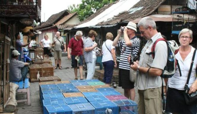
Ngasem, Bird Market

Ngasem, Bird Market

In the past, amongst the Javanese community especially the noble community (priyayi), the possession of material symbols identified social status and prestige. One of the symbols was birds. For Javanese people, having birds as pets was a symbol of klangenan and social status. This also identified one`s high taste on hobby.

Where the belief came from, when it was started, and why the Javanese noble men liked to raise birds, is still a mystery. The birds were usually the ones that had beautiful chirp, especially perkutut and other high selling price birds. However, the fact that raising beautiful chirp birds became tradition and that certain birds became the measurement of social status, had become special everyday life of Javanese people.

Ngasem, Bird Market

Thus, a bird market was built. As a bird market, Pasar Ngasem (Ngasem Market) has operated since 1809. This makes Pasar Ngasem the oldest bird market in Yogyakarta. But, that time, Pasar Ngasem had not yet been the center of bird trading, because the bird sellers were still spread all over the place in Yogyakarta.

Far after that, in 1960`s there was a policy from the city government that all birds sellers in Yogyakarta, including those who were in Pasar Beringharjo (Beringharjo Market) to move their business to Pasar Ngasem. Now, Pasar Ngasem is the center of birds trading. Besides perkutut, there are also kutilang,  kepodang, emprit, prenjak, jalak, and parkit, that the buyers hunt or are sold out with high price.

Besides the historical and cultural values above, the market has a certain atmosphere making it different from the other bird markets. The chirps of hundreds of birds and the noise of the people inside the market can already be heard once visitors step their feet in front of the market. Besides seeing the trading activity, visitors can also listen to the conversation/transaction between the seller and the buyer which is done in Yogyakarta special terms. To understand the conversation, visitors can ask their guide to translate it for them.

Ngasem, Bird Market


In this market, visitors can enjoy a few shows held by bird lovers. Some of the shows are skill performance by pigeons to fly out and back in to the cage, and chirp competition of kinds of birds. Because of that show, the buyers are very impressed and interested in the birds and willingly pay no matter how much the cost. The sellers sometimes also train the birds to sing or chirp beautifully, and share some tips on how to raise birds.

Although Ngasem is a bird market, we can also find snakes, fish (at the west part), iguanas, dogs, cats, civets, rabbits, and roosters of all kinds there.

Ngasem, Bird Market


Just like any other traditional market, Ngasem also provides market snacks. One of the special snacks is jenang gempol (made of rice flour that tastes salty mixed with coconut gravy and sweet java sugar syrup) that can be found in front part of the market. Other snacks are getuk, lupis, thiwul, and gatot. Besides the bird kiosks, there are also food stalls (warung) that offer soto and nasi rames. Besides that, visitors can also find Yogyakarta special jamu gendong (jamu: tonic made of medicinal herbs. There are kinds of tonic, and each of them has special function. The sellers put the tonics in bottles inside a basket and carry the basket on their back around the market.

Pasar Ngasem Location

Pasar Ngasem is located in Jalan Polowijan, Keraton, Yogyakarta City, D.I Yogyakarta Province. The market is around 400 meters west of Keraton Yogyakarta (Yogyakarta Palace). From Taman Sari (Water Castle), which is right at the south of Pasar Ngasem, we can see the market very clearly. 
From the center of the city, that is Malioboro or Keraton Yogyakarta, visitors can take becak (pedicab) or andong (Yogyakarta carriage) to get to Pasar Ngasem. With andong, it will cost around IDR 10.000, while with becak, it will cost IDR 15.000 . Both transportation means will take 10 to 15 minutes to get to the location.

Around the market, there are food stalls (warung) that offer kinds of food such as: sate, soto, lotek, gado-gado, gudeg-yogya, etc.  Souvenir shops that sell Yogyakarta crafts can also be found there. If visitors need any information about Yogyakarta, they can get it from Polisi Pariwisata (Tourism Police) who wears brown uniform and maroon tie that stands by at the tourism place.

Wednesday, December 10, 2003

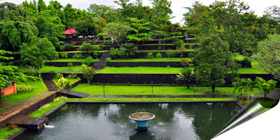
Wonderful of Narmada Park in Mataram City

Wonderful of Narmada Park in Mataram City
Narmada Park

Like other kingdoms in Nusantara (Malay archipelago), Bali Kingdoms which had ever ruled in Lombok Island built many parks as places for the kings to rest and enjoy the nature after the tiredness of managing the kingdom affairs. There are some equipments inside the parks which are usually used to amuse the kings. Different from other parks in West Nusa Tenggara, this park was built as a place for the kings to worship and do their rituals.

Narmada is a park which was built by King Anak Agung Gde Ngurah Karangasem in 1727 A.D. However, most of the history books write that it was built in 1805 A.D. The name of the park is taken from a holy river in India, that is Narmada River. This park is similar to Mount Rinjani and Lake Segara Anak. It is said when the king was too old to do the ritual and sacrifices (pekelan) in the peak of Mount Rinjani which has 3726 meters height, he ordered all architects in the kingdom to bring the nuance of Mount Rinjani to the center of the city. Finally, they agreed to make the duplicate, that is Narmada Park. In the past, Narmada Park was a place which was used by the kings not only to worship Dewa Shiwa (Shiva Deity), but also to take a rest.

Nowadays, Narmada Park is opened for public and becomes the center of recreation which is always visited by many local and foreign tourists. This park is always crowded on the weekend.

If you are a nature lover, but you are too busy and do not have much time, it is a right decision to spare your time visiting Narmada Park. The concept of this park has a special characteristic of exotic nature nuance which is arranged to imitate the form of mountain. On the below part, there are three ponds which are irrigated by clear spring like a lake. The amount of the pond is the same as the amount of Lake Segara Anak in the peak of Mount Rinjani. Inside this park, there is a temple named Kalasa Temple which is located in the above of the park. To reach this temple, you have to pass tens of stairs which was made intentionally so that you will feel like climbing Mount Rinjani. It is pretty exhausting to reach the top peak of Kalasa Temple. However, the tiredness will be erased by the nature situation that is still fresh, the shady trees, and the natural swimming pool with clear water.

Wonderful of Narmada Park in Mataram City


Between November and December, this park will be seen as piety center. The Lombok natives who embrace Hindu religion usually celebrate Pujawali Day in this month by climbing Mount Rinjani and doing pekelan ritual by throwing stuffs and small jewelry to honor the God who keeps Mount Rinjani. People who cannot go to the mountain just have to go to the temple in this park.

Another interesting thing is the pond water in Narmada Park originated from the spring which comes from Mount Rinjani. This spring is believed to be able to make someone looks younger than his real age is. You can try it by washing your face or drinking it.

Where Narmada Park Access Location?

This park is located in Mataram City, province of West Nusa Tenggara, Indonesia. For tourists who want to visit Narmada Park, the trip to the location needs about 20 minutes from Mandalika bus station in Mataram City using public transportation. The tariff of public transportation is  4.000,00 IDR and taxi is 25.000,00 IDR. To enjoy this miniature of Mount Rinjani, the tourists only have to buy tickets 2.000,00 IDR for adults and 1.000,00 IDR for children. This park is opened for public and starts from 7 a.m. until 6 p.m. (Middle Indonesia Time).There are not many hotels around this location. The tourists usually stay in hotels which are located in Mataram City.

Thursday, November 20, 2003

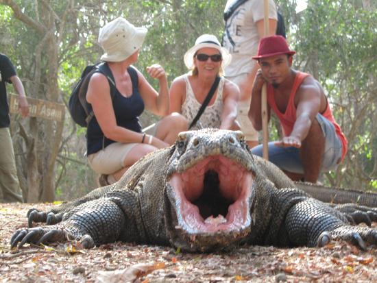
Wonderful of Komodo Island

Wonderful of Komodo Island

Having arrived there, Lieutenant Steyn and his crew saw giant lizards which length was up to two meters. Steyn could kill one of those giant lizards and brought it to his office in Ende City. Then, this giant lizard was photographed and the picture was brought to Peter A. Ouwens, a director of Zoological Museum and Botanical Garden in Bogor. This was the first documentation of a giant lizard named Komodo. Therefore, in 1910 the Netherlands named the island as Komodo Island.

The result of that photography was published by a national daily newspaper of Netherlands in 1912. This publication made Komodo Island visited by the researchers, missionaries, and tourists. Realizing that Komodo was a special rare animal in 1915, the Netherlands government issued a rule about protection to this animal from hunting and killing.

Wonderful of Komodo Island


As the name, Komodo Island is an island which is known as the original habitat of Komodo (Varanus Komodoensis). The local people calls this animal as Ora. Until present day, Komodo still becomes a pride because it becomes a source of income for local people from the tourists who visit the island.

In this island, tourists can see Komodo which is the biggest lizard species around the world, with length of the body up to 3,13 meters and weight up to 165 kilograms. The tourists also can see several activities of this rare animal, such as the Komodo copulate which always happens between May until August; Komodo which is eating deer, goats, and pigs; and see Komodo which is sun-bathing on the road and on the branches of trees in the morning.

Wonderful of Komodo Island
Komodo National Park


In 1980 the government made Komodo Island as the Komodo National Park to protect Komodo from extinction. Six years later, in 1986, this national park was accepted as the World Inheritance Site by UNESCO. This national park consists of two big islands. They are Rinca Island and Padar Island surrounded by several small islands. The total wide of this national park was 1.817 kilometers square.

Komodo Island Location

Komodo Island is an island located in the western area of East Nusa Tenggara Province bordered to the West Nusa Tenggara Province. Administratively, this island is included in the Komodo Sub-district, West Manggarai District, East Nusa Tenggara Province, Indonesia.

From Kupang, the capital of East Nusa Tenggara Province, tourists can go by plane to Ende, a city in Flores Island. The journey is continued to Labuhanbajo City for ten hours by minibus. From the city located in the most western area of Flores Island, the journey is continued to Komodo Island by speed boat for about two hours. The foreign tourists are charged US$ 5 per person for one day, and local tourists were charged IDR 25,000 per person. In this island, tourists can find international resorts, several cottages provided by local people, and restaurants as well.

Tuesday, November 4, 2003

Muara Kuin Floating Market in Banjarmasin City

    Muara Kuin Floating Market

    Muara Kuin Floating Market is one kind of trading interaction patterns of people who live above the water. The sellers and buyers conduct the trade on boats called Jukung (Banjar Language). The trade activities start after morning prayer and usually end when the sun has moved up about 9 a.m. (Middle Indonesia Time). Late that that, the market is deserted by the traders who go along the river, selling their stuff to the inhabitants living along the river.  
    This floating market has existed since more than 400 years ago and this is the proof about the trading activities of people who live above the water. Like markets in the land, on this floating market, trading commodities, such as vegetables, fruits, fishes, and other household needs are also sold. The first buyer is called dukuh while the second buyer who buys from the first hand to be sold again is called panyambangan. In this market, visitors can watch the trading transaction which is done traditionally by bartering amongst boating traders. In Banjar Language, it is called bapanduk.
    Unfortunately, the attractive condition of trading activities on boat gradually loses its fame, not only because of the decreasing amount of the local traders, but also because of traders‘ attitude which is not friendly anymore and the lack of support from the government of Banjarmasin City. The government policy to build market in the land nearby Muara Kuin floating market and hundreds of low bridges which block the river traffic access directly or indirectly, is one the causes make the trading activities disappear in this floating market.


    Visiting Muara Kuin floating market will give unforgettable memories about how the people who live above the water complete their daily needs. Besides, visitors will also know the trading transaction pattern which have existed since more than 400 years. Because this market has become a witness of economic activity journey of South Kalimantan society, a familiar saying appears that “if you have not yet visited Muara Kuin floating market, you have not gone toBanjarmasin”. The jostling situation between big boats in this floating market is pretty unique and special. The jukung drivers with his skill of chasing the buyers or the sellers who hang around and oaring their boat which often shakes because ofBarito River wave. Tourists who come from big cities will feel different sensation when seeing woman traders with their wide hat riding in a boat to sell garden products or food made by themselves. Floating market does not have organization as market in land, so it is not recorded how many traders and visitors, the traders division based on commodity, and places to sell which always move. Visitors who only want to relax can enjoy a cup of tea or coffee and food/cookies from Banjar, while enjoying the shaking wave which spring upon the klotok (motorboat) that is ridden. Visitors can also see floating houses (Lanting House) which are located along the river side.

    How to Muara Kuin Floating Market Access Location?

    Muara Kuin floating market is located in the current of Barito River, exactly in the estuary of Kuin RiverNorth Banjarmasin Sub-districtBanjarmasin CitySouth Kalimantan Province.If leaving from the center of Banjarmasin by using motorboat or usually called klotok, it needs about 45 minutes to reach the market which is located in the current of Barito River.If you want to reach it earlier, visitors can use land transportation by taking Banjarmasin City – Alalak Village route. From Alalak Village to the location of floating market which is not really far, visitors can charter klotok which costs 70.000,00 IDR (based on charters‘ ability to bargain). By renting klotok, visitors are not only able watch the activity in the floating market, but also invited to picnic to Kembang IslandThis place provides renting place for klotok boat, restaurants, stall which sell food and soft drinks. Besides, in this market, visitors can spend the night in Lanting House which stands in a line in the river side.

Thursday, October 16, 2003

The Story Line of Kiskendo Cave

The Story Line of Kiskendo Cave


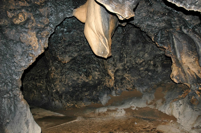
Kiskendo cave, which was named Guo Kiskendo by the local people, was found firstly by a hermit named Ki Gondorio in 1700‘s. The hermit was also the first cave keeper. According to the local story, one night the hermit had a dream of entering a cave that looked like a palace. In the dream, Ki Gondorio got a guidance to name the 15 rooms in the cave. After he woke up, Ki Gondorio followed the guidance that he saw from the dream.

Despite there is a story like above, the local people have their own versions. Some say that the cave came from the wayang world. The version tells that once upon a time, Kiskendo cave was a kingdom ruled by a king named Mahesosuro. Some other say that the cave is the duplicate of another cave in India.

The Story Line of Kiskendo Cave


Until now, the local people still think that Kiskendo cave is a sacred place. This relates to the myth or legend it brings, the places inside the cave that are often used for some ascetic activities or meditation, and the rules that forbid anyone to litter the cave, insult or damage it, and do immoral activities inside the cave.

Tourists can search the story line of Kiskendo cave that is being related to the wayang story (Ramayana epic) which is carved to the relief in front of the cave.

The Story Line of Kiskendo Cave


Kiskendo cave is a complex of tourism object which consists of a few places. Rumor has it, this relates to the legend that came with the cave, which is Kiskendo Kingdom. There are 15 areas in the cave, they are:


  • Lidah Mahesosuro (Mahesosuro Tongue), is a rock that has a tongue. People say that this rock was King Mahesosuro‘s tongue which was cut by Subali to prevent him from being risen from the death.
  • Pertapaan ledek (Ledek Retreat), is a place for artists to meditate for gaining success in their job.
  • Pertapaan Santri Tani (Farmers Retreat), is a place for farmers to meditate and pray for good harvest. Farmers around the cave in the old times often lived in this place.
  • Pertapaan Subali (Subali Retreat), is a place Subali meditated before fighting against Mahesosuro and Lembusuro (ox-headed man).
  • Sumelong, is a hole that leads to the top of the cave. Myth has it that Subali used the hole (it is in the middle part of the cave) to get out from the cave since Sugriwo closed the way out of the cave.
  • Lumbung Kampek, is a place to keep valuable things from the Kingdom of Kiskendo Cave.
  • Selumbung, is a rice barn of the Kingdom of Kiskendo Cave.
  • Gua Seterbang (Seterbang cave), is a cave that still becomes the part of Kiskendo cave. People say that this cave connects to the Indian Ocean (south of central java).
  • Keraton Sekandang (Sekandang Palace), is the center of Kiskendo Cave Kingdom. In this place, Subali fought against Mahesosuro and Lembusuro.
  • Kusuman Retreat, is a place of meditation to gain a higher status.
  • Padasan, is the well at the time of Kiskendo Cave Kingdom.
  • Sepranji, is the center of animal farming at the time of Kiskendo Cave Kingdom.
  • Babat Kandel, is rocks that look like human‘s intestines. According to the local story, this babat was Mahesosuro‘s intestines that were thrown by Subali.
  • Sawahan, is a place to plant rice.
  • Selangsur, is a place where the soldiers of Kiskendo Cave Kingdom fought Subali.
  • Besides the 15 places above, there are other objects near the complex of Kiskendo Cave, they are Sumitro Cave (about 50 meters), Grojogan Sewu (a waterfall with of 20 meters height), Watu Blencong  (around 250 m above Kiskendo cave), Mount Krengseng, Watu Gajah, and Mount Kelir (limestone mountain shaped like a sail, about 4,5 km from Kiskendo cave).

Kiskendo Cave Location

Kiskendo cave is located at the area of Menoreh mountain which is part of the administrative territory of Dusun Sukamaya, Jatimulyo Village, Girimulyo Sub-district, Kulon Progo District, D.I Yogyakarta Province. This cave is at the south western part Wates, the capital city of  Kulon Progo District, and is about  800 meters height above the sea level.


To get to the cave location which is about 35 km from the city of Yogyakarta, tourists can take the bus from the Center Terminal of Giwangan Yogyakarta. From the terminal, the tourists can choose the bus with Yogyakarta-Sentolo route or Yogyakarta - Wates route that costs IDR 10.000 (February 2008). Usually, the buses that operate in those routes have dark color and smaller in size compared to the city bus.

From Terminal of Giwangan, it takes 40 minutes. Do not forget to tell the conductor to put you down in the Ngeplang three-junction. From the junction, tourists have to take another bus with Samigaluh or Nanggulan route. This costs Rp. 15.000 and 50 minutes travel to get to the Kiskendo cave. In the tourism area, there are toilets, resting place (pendopo), and vast parking area (for buses, cars, and motorcycles).

Monday, October 6, 2003

Bau Nyale Festival in Lombok Island

    Bau Nyale Festival in Lombok Island
    Bau Nyale Festival

    The festival “Bau Nyale in Sasak language means “menangakap nyale” (catching nyale). Nyale is a kind of worms usually living at the bottom of the sea, such as in the holes of corals. This activity is held every the 20th of the 10thmonth of Sasak calendar or five days after the full moon. Usually this event occurs in March. The main program on this festival is catching nyale that only appears once a year in some particular locations in South Beach of LombokIsland. The Nyale will appear in the middle of the night until nearly dawn.
    According to the local tale, long time ago along the South Beach, there was Tonjang Beru kingdom led by a king who has a beautiful princess named Princess Mandalika. Her beauty made many princes in Lombok Island charmed. Because of many proposal to her and Princess Mandalika could not choose one of the princes, she decided to plunge into the South Beach and promised that she would be back once a year. Like what she said, she comes back every year, but in the form of nyale. Other tale says that nyale is the transformation of Princess Mandalika`s hair.

    Bau Nyale Festival in Lombok Island

    Before the main celebration begins, there are many arts and traditional events performed. If you are interested in them, just come at noon. You can build small tents to rest awhile. From these tents, you can watch Betandak (exchanging quatrains), Bejambik (granting souvenir to lovers), and Belancaran (taking a pleasure trip by a boat). Moreover, there will be Princess Mandalika colossal drama performance. 
    Many visitors from different area come to Lombok Island just to see the noisy and crowded situation when catching nyale. This festival shows togetherness situation where the people come together to find nyale massively. You are also permitted to participate in finding nyales in this location. If you are lucky enough, you will get many nyale. According to Dr. dr. Soewignyo Soemohardjo`s research, nyale has high protein and they are able to produce a substance which has been proved able to kill germs. The common way to cook nyale amid Lombok society is by wrapping nyale with banana leaves and then burning it. It is commonly called pepes (roasted fish).

    Where Bau Nyale Festival Location?

    Nyale always appear in the South Beach of Central Lombok which is exactly in 16 points which scatter for tens of kilometers from the East until the West, such as the coast of Kaliantan Beach, Kuta Beach, and Selong Belanak Beach. These beaches are surrounded by hill lines. However, the most crowded beach visited by many tourists is Seger Beach located in Kuta VillagePujut Sub-district, Central Lombok DistrictWest Nusa Tenggara ProvinceIndonesia

    To reach Kuta Village, tourists can use public transportation from Mandalika Terminal (Mataram City) to Praya (the capital of Central Lombok) which is about 30 kilometers. From that location, there is no transportation which go directly to the tour location. Therefore, you can rent a car to get to Kuta VillageTo enjoy the beauty of Seger Beach and else while catching nyale, tourists do not have to spend money. Those beaches still become open beaches and have not been made as tour location by local government, except for Kuta Beach.  
    If you are interested in this tour, the equipments that you have to provide are flashlight, net, and container for nyale. However, many local people usually provide those equipments.
    In the past, this village was quiet enough, but since this festival was loved by the visitors very much, many motels and moderate inns was built around the tour location. Besides, there are also many small stalks and restaurants which offer various kinds of special food from Lombok Island.

Monday, September 29, 2003

Batuah Agro Tourism in Samarinda-Balikpapan

    Batuah Agro Tourism in Samarinda-Balikpapan
    Batuah Agro Tourism

    Batuah agro tourism is a tourism object based on agro business in the district of Kutai Kartanegara, East Kalimantan ProvinceIndonesia. This garden was officially declared on July 8th 2000 by the then Governor of East Kalimantan. The total area of the garden is 35 hectares, filled by various plants, such as ornamental plants, fruits, medicinal plants, and other scarce plants.
    The garden has almost 914 kinds of plants, including vegetables and fruits. Specifically, the number of the fruit plants in this garden is 50 kinds from 75 varieties. Many fruits can be found there such as rambutan (lychee), durian, salak(zalacca), elai and guava. This garden becomes conservation garden and place for germ plasma collection in special horticulture plants.

    Batuah Agro Tourism in Samarinda-Balikpapan


    In this garden, the visitors are allowed to eat the fruits freely. But, if the visitors want to take those fruits home, they will be charged, especially for rambutan, about 3,000.00 IDR/kg (February 2008). Besides that, there is a fishing pool open for public. The visitors who want to fish are not charged, but if they wanted to take the fish home, it will be charged about 20,000.00 IDR per kilo. 

    Batuah Agro Tourism in Samarinda-Balikpapan

    Where Batuah Agro Location?

    Batuah Agro Tourism located in Samarinda-Balikpapan street KM 38, sub-district of Loa Janan, district of Kutai Kartanegara, province of East Kalimantan, Indonesia. The travel from Samarinda to the location needs approximately 50 minutes; from Balikpapan needs about 75 minutes through Hutan Rakyat Bukit Suharto (National garden) The visitors could use private and public transportation as well, both from Samarinda and Balikpapan. There is veranda that can be used as a resting place, sholat (Prayer), and other things. The visitors can enjoy other facilities in this area as well, such as jogging track and camping area.

Friday, September 19, 2003

Kampoeng China

Kampoeng China
Kampung China

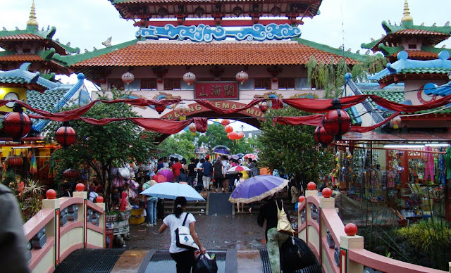
Kampoeng China is a residence and trade village in Cibubur, East Jakarta. This village is one of the cooperation between East Jakarta Regional Government and a foreign company to make the 300-hectare in Cibubur tourism area become Kota Wisata (Tourism City), Kota Mandiri (Independent City), and Town Center. This Kampoeng China started operating on September 14th, 2002. The building, nature nuance, until accessories which are sold in this place have Chinese nuance. All sold products come from China and the cost starts from thousands rupiah up to millions rupiah. On ordinary days, this village is crowdedly visited by the people around the area. This situation will be more crowded in Chinese New Year or Imlek celebration day.

Before entering this village, the visitors have already felt the Chinese nuance reflected on the gate in the form of red dragon. It is called the prosperity gate. Next, the visitors will pass a curving bridge called Dragon Gate above a Chinese nuance pond. Then, they reach the center of the crowd named the forbidden city. The Mandarin music which is heard since entering the gate until inside the main location takes the visitors as if they were on bamboo curtain land.

When entering this Kampoeng China, the visitors will find shops line selling various kinds of Chinese merchandises, such as fans, umbrellas, wall decorations, tables, hair pins, rings, clothes, gloomy lamps, towels, bags, shoes, electronic goods, various porcelains, jars, Chinese incenses, money gifts, and Chinese traditional medicines. The narrow streets which connect the blocks are decorated with an amount of lantern balls.

If the visitors are tired to go around enjoying the situation of Kampoeng China or shopping, they can get relax in some benches while enjoying the scenery of the well-arranged shops or parks with some small ponds, or tasting various foods and drinks which are arranged in lines in a special block.

Amongst the uniqueness of Kampoeng China are the buildings, statues, and merchandise accessories which have bright red color. Another uniqueness is that most of the visitors in fact are not Chinese descendant, but native people who not only come from surrounding area but also come from other big cities in Indonesia. The visitors can go not only for recreation but also for shopping.

The beauty of Kampoeng China architecture is reflected in 200 shops which are well-arranged in lines and sell Chinese accessories. The building, cultural tradition, and art which are shown bring the visitors‘ imagination into Chinese culture and art. The visitors will be amazed and astonished with the Chinese completeness and nuance which are dominant in this place.

Amongst the uniqueness of Kampoeng China are the buildings, statues, and merchandise accessories which have bright red color. Another uniqueness is that most of the visitors in fact are not Chinese descendant, but native people who not only come from surrounding area but also come from other big cities in Indonesia. The visitors can go not only for recreation but also for shopping.

The beauty of Kampoeng China architecture is reflected in 200 shops which are well-arranged in lines and sell Chinese accessories. The building, cultural tradition, and art which are shown bring the visitors‘ imagination into Chinese culture and art. The visitors will be amazed and astonished with the Chinese completeness and nuance which are dominant in this place.

Kampoeng China Location

Kampoeng China is located in the housing estate area of Cibubur Tourism City, not far from Cibubur campsite, East Jakarta. Kampoeng China is easy to find. From Jakarta, the trip is about 45 minutes through Jagorawi (Jakarta, Bogor, and Ciawi) freeway. From Depok, the trip is about 20 minutes. From Bogor, the visitors can go through Cileungsi or the freeway. This Kampoeng China tourism is opened everyday, started from 12.00 - 20.00 WIB. On Saturday and Sunday, it opens from 10.00 WIB. Inside this tourism area, the visitors can also see Pagoda Lung Hwe, Thai San Tower, and Huang Shan Tower. This place also provides inns, restaurants, and special blocks which sell food and soft drink.Inside this tourism area, the visitors can also see Pagoda Lung Hwe, Thai San Tower, and Huang Shan Tower. This place also provides inns, restaurants, and special blocks which sell food and soft drink.

Thursday, August 14, 2003

Visiting Gembiraloka Zoo Yogyakarta

Gembiraloka Zoo

The zoo well known as Gembiraloka is the only zoo in Yogyakarta. Although it is a zoo, Gembiraloka is still categorized as a museum included in category of zoologicum museum or fauna museum and special museum. Seen from the historical perspective, Gembiraloka is  the second oldest museum in Yogyakarta after Sonobudoyo Museum.

In 1933, the idea of the development of the zoo around Gajah Wong River emerged from the King of Mataram, Sri Sultan Hamengkubuwono VIII. The Sultan wanted a tourism or entertainment area for the people in the form of botanical garden (kebun rojo). Then, Sri Sultan consulted this idea to an Austrian architect named Kohler. Nevertheless, the establishment of this zoo just could be realized by Sri Sultan Hamengkubuwono IX and Ir. Karsten (an engineer) in 1953. Still in the same year, on November 10th, 1953, Gembiraloka Zoo, which was managed by Gembiraloka Foundation, was officially opened by the Sultan himself. At that time, this foundation was led by Sri Paduka Paku Alam VIII.

Elephant Attraction


In the development, due to many managerial reasons, the Gembiraloka Zoo has changed its manager for several times. Although it has experienced many difficult situations   this zoo still becomes one of the main tourism objects in Yogyakarta. The data from Tourism Agency of Special Region of Yogyakarta for the last five years shows that the number of visitors to Gembiraloka in every year is more than to the Museum and Monument of Jogja Kembali. The quantity of the visitors in Gembiraloka can only be compared by the visitors of Yogyakarta Palace and Malioboro area.

Unlike other zoos in general that only show “ordinary” or rare fauna for display in the iron bars cage or wooden fence, Gembiraloka also presents dried preservation of some animals in a special room similar to a museum. The museum presenting this preservation animals is located in the side of the artificial lake in the zoo area. In 2007, Gembiraloka built not only the particular building for the preservation, but also a natural laboratory for flora and fauna as a studying media for people, especially for children. In this place, the visitors can enjoy various kinds of insects, vertebrate or invertebrate.

The zoo area which has been more than a half century is facilitated by a beautiful park,  decorated by various kinds of big and shady old trees, and beautiful flowers. As an arboetorium, Gembiraloka provides an observation area for forest plantation and the seedbed area which grow naturally. These various kinds of plants are not well-managed to show the “natural” atmosphere like other zoos in general.

Penguin Jascas


Besides getting real knowledge about various kinds of fauna and flora in the zoo, the tourists who take their children are also provided by tour boats look like a swan that is rowed (usually called genjot bebek). For the visitors that have not been ridden an elephant, the Gembiraloka Manager provides a special recreational facility, such as traveling around the zoo by tame elephants. Moreover, a children playground and an artificial cave are also provided as the supporting accessories of the zoo.

Gembiraloka Zoo Location

The address of Gembiraloka is in Kusumanegara Street, Yogyakarta City, Yogyakarta Special Region Province. This zoo is about four kilometers from Giwangan Terminal, Yogyakarta. If the tourists are from the downtown, Malioboro or the Yogyakarta Palace, the distance is about six kilometers. 

This zoo is opened everyday for public from 8 A.M. until 5 P.M. The visitors can use any kinds of public transportations in Yogyakarta to reach this tourism object. They can go by becak (pedicab), andong (four-wheeled carriage drawn by one or more horses), city bus, Trans Jogja bus, and also taxi. If the tourists choose becak or andong, they have to make sure that they are not too far from the zoo because the cost will be more expensive. If the tourists want to use a bus, chose number 9 or 7 which costs IDR 2.000,00. If the visitors choose a Trans Jogja bus, they may come to a Trans Jogja bus station and go with the bus route 1B. This route will stop in the station nearby Gembiraloka Zoo. The cost of Trans Jogja bus is IDR 3.000,00.

The ticket cost is still in confirmation. However, there are two kinds of ticket costs that are valid in this zoo. The first ticket is the personal ticket and the second ticket is the group ticket (more than twenty people). The lines of the shops that sell souvenirs, children toys, food, and beverages, can be found around the parking area. This zoo also has a large parking area for big busses, cars, and motorcycles. Besides, the rest rooms and musholla (small building for the Moslems to pray) become other facilities in this tourism object.

Wednesday, August 13, 2003

The Wonderful of Lake Tempe in South Sulawesi

The Wonderful of Lake Tempe in South Sulawesi
Lake Tempe

Lake Tempe is a tourism destination in South Sulawesi province that are frequently visited by tourists either domestic or foreign. The lake, which is 13.000 hectare in width, seems like a giant washbasin when it is viewed from above. Subsistence for people living around, it is not only used by the inhabitants of Wajo district, but also other people in the districts of Soppeng and Sidrap. Along the lakeside, you can observe the fishermen`s floating houses which were built in Bugis nuance, standing in a row directly face to the lake.

Lake Tempe is the biggest wetland fishery area in the world. It is assumed that the lake is located on the meeting point of two continents. Therefore, many wetland fish species can be found there than the other places in Indonesia.  In the middle of the lake, the fishermen`s floating houses stand in a row decorated with colorful flags. Above those, you can watch sunrise or sunset in the same position while enjoying various species of birds, fishes and water grasses. 


The Wonderful of Lake Tempe in South Sulawesi


At night, it is the right time to angle for fishes while enjoying the beauty of moon lighting the lake.On every August 23, a sea festival usually called Maccera Tappareng (literally means purifying the take) is started, signed by butchering a cow that is led by the fishermen leader. You can watch many interesting attractions such as traditional boat race, decorated boat competition, kites competition, the election of Ana` dara (princess) and Kallolona (prince) of Wajo district, Padendang (beating mortar), traditional music performance, Bissu dance played by transsexuals and other traditional performances. It is aimed to keep the unity and the familiarity among the fishermen by “3-S” principals, Sipakatau, Sipakainge, and Sipakalebbi (Respecting, advising, and appreciating each others). Watching these performances, you will know more about Bugis culture especially Bugis in Wajo district. 


Where Lake Tempe Location?

Lake Tempe is located in Tempe sub-district, Wajo districtSouth Sulawesi province. Lake tempe lies 7 km away from Sengkang city, the capital of Wajo district. To reach the destination, you may take any public transportation such as Pete-pete (Minibus) from Sengkang city to the Walennae River continued to LakeTempe from the Walennae River in 30 minutes by using Katinting (Motor boat). Its cost is about Rp. 50.000 to Rp. 75.000 / person. If you are eager to enjoy fishing at night while enjoying the beauty of the moon lighting Lake Tempe, you are allowed to spend the nights in the fishermen`s floating houses. 

Friday, July 11, 2003

Trekking in Mount Singgalang Bukittinggi

Trekking in Mount Singgalang Bukittinggi
Mount Singgalang

There are many mounts in West Sumatera province, one of them is Mount Singgalang that is located in Agam district. It is at an altitude of  2.877 meters. Mount Singgalang covers some forestry areas, the Dipterocarpaceae Hilly Forest, the Dipterocarpaceae Upper Forest, the Montane Forest and theEricaceous Forest (Mountainous Forest). The Dipterocarpaceae Hilly Forest is at an altitude of 300 meters to 750 meters with the main plants are Seraya wood, Keruning wood, and Meranti wood. The Dipterocarpaceae Upper Forest is situated at an altitude of  750 – 1.200 meters with Meranti Bukit wood, and Damar Minyakwood as the main plants. The Montane Forest lies at an altitude of 1.200 to 1.500 meters above sea level with Mempening wood, Berangan wood, Damar Minyak wood and Podo wood as the main plants. The Ericaceous Forest or mountainous forest is located at an altitude of 1.500 meters with Kelat wood, Periuk Kera wood as the main plants. On the peak of the mountain, you will find two ponds named “Telaga Dewi” and “Telaga Kumbang.”


Trekking in Mount Singgalang Bukittinggi
Telaga Dewi


Mount Singgalang can be reached by land from Ketapig Airport to Bukittinggi in approximately 2 hours with Rp. 10.000,00 – Rp. 15.000,00 for its costs. To reach the top of the montain, there are three ways that can be accessed, Pandai Sikek way (form Koto Baru), Kenagarian Malalak way (from Toboh) and Balingka way. If you decide to climb by Pandai Sikek way, it is started from Padang city to Koto Baru and continue to Pandai Sikek by any accessible public transportation. However, if you start the trip by Balingka way, it will be started from Padang to Bukittinggi (Padang Luar) continue to Batu Tagak. The last route to reach the destination is Tobah way, it is started from Padang to Bukittinngi continue to Tobah by any public transportations. Belows are the costs for transportation:
    • Rp. 3.000 through Pandai Sikek way
    • Rp. 2.500 – Rp. 4.000 through Balingka way
    •  Rp. 3.000 – Rp. 5.000 through Tobah way

Where Mount Singgalang Access Location?

Mount Singgalang lies in Bukittinggi nearby Mount Merapi, but geogrpahically, it is located in Agam district, West Sumatera province. You may spend more nights as there are many hotels that can be found. There are two natural tourism destinations, Mount Singgalang and Mount Merapi. You will be offered with the various local cuisines from Padang that are commonly called Masakan Padang.

Wednesday, July 2, 2003

Andong, Traditional Transportation in Yogyakarta

Andong, Traditional Transportation in Yogyakarta
Andong Yogyakarta

Andong or Dokar is one of specific transportations from Yogyakarta. It is also known as delman, bendi, or sado. An anthropologist who once did a research on Andong indicated its small shape as the differing factor of andong in Yogyakarta to the ones in other different places such as Surakarta and Cirebon.

Andong was historically a chariot with 4 wheels, which was used only by the noble people, the Kings and their relatives for particular event. It was one of the icons to indicate social status of the priyayis (the royal families) in the early 19th century to the 20th century. The story started when Mataram Kingdom was led by Sultan Hamengkubuono VII (around the early 19th century). The lay people were not allowed to use andong during that period. They could only use a gerobak sapi (a chariot pulled by cattle) or a dokar for transportation. Andong was gradually available for the lay people during the leadership of Sultan Hamengkubuono VIII. It was limited for the traders and merchants though.

Going around the city with Andong is an interesting experience that tourists might not have at other places. To enjoy such an experience, tourists can choose the andong they wish. There are 2 kinds of andong in Yogyakarta: the regular Andong (which is also known as ‘not for tourism andong‘, and ‘for tourism andong‘.

Andong, Traditional Transportation in Yogyakarta
Kusir Andong


Tourists can easily identify andong, which are meant for tourism because they are clean, well taken care of, and relatively new. The number of each andong is written in Javanese letters and put on the front side.

Besides, tourists will also be able to see the driver (kusir) in complete Javanese outfit: the blangkon, sorjan and lurik, and a black ¾ size pants. The friendliness of the drivers and their broad knowledge on the history of the city contributes special taste of the andong in Yogyakarta.

Andong Location

Andongs are generally available at the city of Yogyakarta, Sleman District, Bantul District, Gunung Kidul District, and Kulonprogo District. However, the andongs for tourism can only be found in Yogyakarta because of their limited numbers (100 units). People will find a number of ‘for tourism andong‘ parked along the jalur lambat (the streets meant for slow ridings), when they go to Malioboro Yogyakarta. They can also find the same kinds around the Beringharjo traditional markets and the North Townsquare (alun-alun Lor) which are located nearby Malioboro. Those who want to try the regular andong can go to any traditional markets in Yogyakarta since they are available there. The cost for renting ‘for tourism andong‘ with the destination Malioboro-the Sultan Palace-Ngasem traditional market-Tamansari-Pojok Benteng-Pathuk-Sosrowijayan-Malioboro is IDR. 20.000-30.000 (data on February 2008).  On the other side, the cost for ‘not for tourism andong‘ usually depends on the destination (how far the place to go is).

Wednesday, June 18, 2003

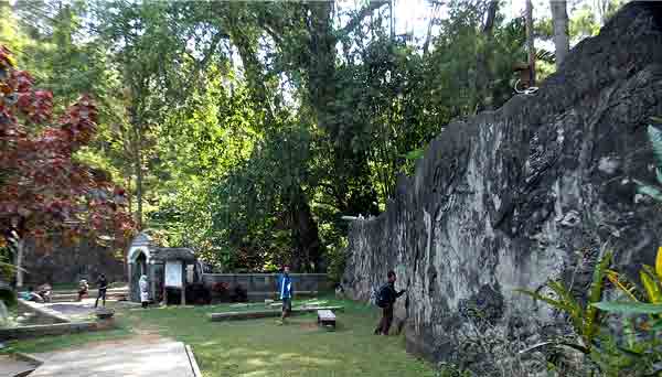
Indarapatra Fortress

    Indarapatra Fortress
    Indarapatra Fortress

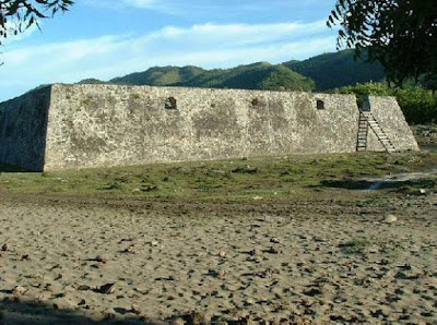
    Indarapatra Fortress was built by the Lamuri Sultanate (The first Hindu Sultanate in Aceh) in the seventh century before Islam came to Aceh. It was built directly face to the Malacca straits for defensive purposes against the aggression of Portuguese. It was Laksamana Malahayati, the first fleet admiral woman in the world, who presided over her soldiers to defend Aceh Darussalam against the Portuguese` aggression.
    Welcoming Visit Indonesia Year 2008, the local government of Aceh Darussalam makes serious efforts to renovate the fortress for the central role of the fortress as valuable historical site. It was big, made of limestone with the unique architecture and solid construction. Now there are only two extent buildings after Tsunami occurred in Aceh four years ago. Moreover, the gate has also broken at the same time. In the past, there were three buildings in the fortress, the biggest one was 70 x 70 meter square with more than 3 meters in height. It could also be found a big room with 35 x 35 meter square and 4 meters high. At the time when the fortress was built, it could be categorized into a futuristic fortress since the people had to climb it first to go inside the building.

    Where Access Location?

    Indarapatra Fortress lies nearby Ujong Batee, Ladong village, Masjid Raya sub-district, in the district of Aceh Besar, Nagroe Aceh Darussalam province.  You may use Labi-labi (The typical transportations in Aceh province) for about 40 minutes. You may also take your own car for approximately 35 minutes to reach the destination. Indarapatra Fortress is 19 km away from Banda Aceh city. The costs for taking Labi-labi for your transportation from Banda Aceh to Krueng Raya is Rp. 4.000,00.  It is hard to find lodgement around the destination, so you have to seriously consider spending more nights there.