• Beautiful Lake Maninjau : West Sumatra Destination

    Lake Maninjau is a volcanic lake that is located at 461,50 meter above the sea level. Its width is 99, 5 km2 with 4, 95 meter of the maximum depth. The existence of Lake Maninjau has created a folktale called "Single Sembilan" (The nine Bachelors). People living around the lake believe that those nine Bachelors are real...

  • Bantimurung Waterfall the Best Destination in South Sulawesi

    Bantimurung waterfall (15 meters in height and 20 meters wide) is a very famous natural tourism destination in South Sulawesi. Pure water falls down from the crag every year. Beneath the waterfall, there is a bathing place made of limestone covered by mineral vein which is caused by the stream flow for hundred years....

  • Nimanga River, Best Rafting in North Sulawesi

    Nimanga River is one of the most favorite tourism destinations in the North Sulawesi. It has been popular as it is used for any kind of extreme sports and other activities. It will be great experience for having an extreme sport such as rafting along the river...

Tuesday, August 17, 2004

Mount Binaiya

Mount Binaiya

Mount Binaiya is the highest mount in Maluku Province. The area of the mount ranges from Seram Island to Manusela National Park (189.000 ha). The rainfall average of the mount is 2.000 mm/year during November to April.

Mount Binaiya

In 1972, Manusela National Park was divided into two areas: Wae Mual (17.500 ha) and Wae Nua (20.000 ha). Wae Mual comprises lowland forestry area in the north. Mangrove, resin (Agathis Alba), and meranti tree (Shorea sp) dominate the Wae Mual area. Wae Nua is situated in the center of hilly area. The width of Wae Nua area is 20.000 ha.


Mount Binaiya is 3.055 meters above the sea level. Having an escapade tour, the mount offers you unforgettable experience ever. In the slope of the mount, you will see meandered rivers which have average width between 6 and 8 meters.

Mount Binaiya

Mount Binaiya Location

Mount Binaiya lies in Central Maluku District, Maluku Province. You may take public transport from Ambon City – the capital of Maluku Province – to Tulehu harbor costing IDR 10.000. From Tulehu, you must continue the trip to Seram Island by speedboat. The cost for taking speedboat crossing Malacca strait is IDR 60.000. From Wahai harbor (Seram Island), you may further the trip to Kanikeh Village for approximately six hours. There is no accommodation and supporting facilities around Mount Binaiya since its location in the hinterland of Maluku Province. However, you may spend more days there in the local inhabitants’ houses.

Wednesday, August 11, 2004

Ulee Kareng Jasa Ayah Coffee Shop

Ulee Kareng Jasa Ayah Coffee Shop
Jasa Ayah Coffee Shop

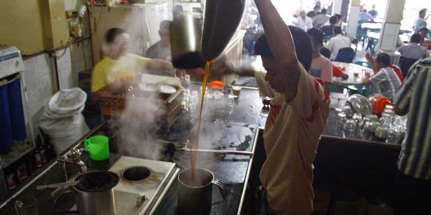
There is a common tradition among the people, especially male, of Nangroe Aceh Darussalam; that is drinking coffee in coffee shops. Nangroe Aceh Darussalam is well known for its numerous coffee shops among other provinces in Indonesia. The difference between coffee shops in Aceh and in Java Island is that the coffee shops in Aceh seem like restaurants. Among the numerous coffee shops in Aceh, Jasa Ayah Coffee Shop is the most popular one. It is owned by Nawawi that has been existing since 1958 by his father, Haji Muhammad.

For Aceh people, coffee shop is more than a place to drink a glass of coffee and some local food of Aceh Province, it is a place to develop social relationship among Aceh people. Moreover, it is also a place to discuss any political issues and economical cases.

Jasa Ayah Coffee Shop is not only famous among Aceh people, but also Indonesian people. Its popularity grew up rapidly after tsunami because many volunteers from either domestics or foreigners came to Aceh. It had also been discussed by International mass media.

Ulee Kareng Jasa Ayah Coffee Shop

Its distinctive taste and its aroma are the best result of the best making process that is made by high quality of Coffee Arabica from Lamno, Aceh Jaya District. Made by special technique full of patient from the frying process (on the lightly frying) until the grinding stage, it produces tasteful coffee. It is better to be served in lukewarm so that the aromatic smell of the coffee can be tasted, even from several meters distance. Moreover, people usually taste it with local cuisines of Aceh like sarikaya cake, timpan cake, bolu cake, martabak telor, nasi gurih (salty rice), and Mie Aceh.

Though Nawawi, the owner of Jasa Ayah Coffee Shop, achieves success in his coffee shop, around IDR 2.000.000 or one a half of coffee in a month, he keeps on being aware of his beyond living. After Tsunami occurring on December 2004, he set a rule that all Muslims must leave the shop when praying times are coming, especially at Dzuhur, Ashar, and Magrib. However, for non-Muslims, it does not matter to stick around in the shop at those times. For him, both world living and beyond living must walk inline.

Ulee Kareng Coffe Shop Location

Jasa Ayah Coffee Shop lies on T. Iskandar Street No. 13 – 14 A, Ulee Kareng Sub-district, Banda Aceh City, Nangroe Aceh Province. Ulee Kareng Sub-district is located in the centre of Banda Aceh City, so there are many public transportations hanging around the location such as taxi, motorized pedicabs, and labi-labi (Ulee Kareng -  Aceh Traditional Market route). As its location in the centre of Banda Aceh City, it will be easy to find some inns or luxurious hotels around the location.As its location in the centre of Banda Aceh City, it will be easy to find some inns or luxurious hotels around the location.

Saturday, July 17, 2004

Gunongan the symbol of Sultan Iskandar Muda`s love to Putroe Phang in Aceh

Gunongan the symbol of Sultan Iskandar Muda`s love to Putroe Phang in Aceh
Gunongan

Gunongan that is situated in Taman Sari (Taman Sari Kingdom) is the symbol of Sultan Iskandar Muda`s love to Putroe Phang, his wife who came from Pahang, Malaysia. As the story goes by, Putroe Phang was full of solitude feeling since the bustle of Sultan Iskandar Muda as a head of state administrations.  She kept remembering her home in Pahang, Malaysia. Fortunately, Sultan Iskandar Muda knew the problem then he built a small mount named Gunongan as a miniature of hills surrounding the Pahang Palace. Since then, Putroe Phang felt exciting. Almost all her times were spent along with other Palace`s ladies by climbing it.

Gunongan is located directly in front of the graveyard of the Dutch fleets. It was built in 1607 – 1636 A.D. on the tenure of Sultan Iskandar Muda in the 17th century. It is not so big; it is hexagonal building which resembling flower with three storeys where on the peak can be found a crown pillar. An entrance door is not too high and keeps on locked. There is a corridor leading to the third storey of the building.

Besides the main building, there is a building called Kandang Baginda. It is a graveyard of the Aceh Sultanate family, one of them is the tomb of Sultan Iskandar Muda`s adopted son, Sultan Iskandar Tsani (1636 – 1641 A.D.) from Malaysia.

The Location of Gunongan

Gunongan lies in Taman Sari Gunongan, Seutui Village, Banda Aceh City, Nagroe Aceh Darussalam Province, Indonesia.Gunongan lies in Taman Sari Gunongan, Seutui Village, Banda Aceh City, Nagroe Aceh Darussalam Province, Indonesia.

Gunongan the symbol of Sultan Iskandar Muda`s love to Putroe Phang in Aceh

It is easy to reach the destination remembering Seutui Village is located in the centre of Banda Aceh City. You can enter the location from the gateway on Teuku Umar Street. There are numerous public transportations around the locations such as pedicab, taxi, motorized pedicab, and labi-labi (typical public transportation of Nangroe Aceh Darussalam). Those public transportations usually pass by Taman Sari Gunungan route, Lhoknga – Aceh Traditional Market, Lamteumen – Aceh Traditional Market, and Lamlagang – Aceh Traditional Market.

Considering the location of Gunungan is in the centre of Banda Aceh City, it will be easy to find either luxurious hotels or middle class hotels around the location.

Tuesday, July 13, 2004

Mount Maras

Mount Maras Adventure

Mount Maras offers you tranquility of green view with scattered farms and leafy trees of surrounding area. Likewise, the mount which is situated at 699 meters above the sea level, presents you wonderful scenery of sunrise in the morning and sunset in the afternoon. We suggest you to bring some foods and tents if you want to climb the mount. There is no food stalls in the surrounding area.

Mount Maras is the only mount in Bangka Island. It offers you magnificent views of its nature and fresh air. The leafy trees in the slope of the mount give you shelter from the sunshine. Spending a night in the location is an unforgettable experience. Flickering lamps of the local inhabitants and twinkling star in the sky are wonderful scenery of Mount Maras in the night. Mount Maras is the right place for hiking, camping, and climbing.

Mount Maras Adventure


Mount Maras Location

Mount Maras lies in Rambang Village, Riau Silip Sub-district, Bangka District, Bangka Belitung Islands. Mount Maras can be reached from either Sungailiat (70 kms) or Belinyu City (33 kms). You can take public transport from Sungailiat to the slope of the mount.

Wednesday, June 16, 2004

Rafting Sensation in the Nimang and Ranoyapo Rivers

 Rafting Sensation in the Nimang and Ranoyapo Rivers

Rafting is a new type of sports that are available in Indonesia. It is a challenging recreational sport pumping up someone‘s adrenalin rush. Just come to the Nimanga River or the Ranoyapo River. There, you will feel the exquisite sensation of exploring the rivers and its distinctive characteristics. There are guides who will accompany you while enjoying the sensation of rafting on the Nimanga River and the Ranoyapo River.

Rafting on the Nimanga River and the Ranoyapo River, which is 35 km long, offers you an unforgettable experience. You will raft above the rough and clean water of those rivers while enjoying magnificent view of surrounding nature and various bird species. This is the right place for having leisure time forgetting any crowded of the city life.

Nimang River Location

The Nimanga  and the Ranoyapo Rivers can be found in Timbukar village, Minahasa District, North Sulawesi Province. The location is about 30 km away from Manado City. You can take minibus from Manado bus station to reach the locations. In addition, taking your own transport will be around three hours to reach those two rivers. You can easily find some hotels nearby the location. Guide services are also available for you there.

Thursday, June 3, 2004

Tour Boats in Glagah Indah Lagoon

Tour Boats in Glagah Indah Lagoon
Tour Boats in Glagah Beach

It would feel a bit incomplete to enjoy the relaxing and refreshing shore of Glagah without getting around on the tour boats. The ride in Glagah Indah Lagoon is a real attraction for visitors especially on holidays. You can feel the hissing waves and breeze on the boat, while beautiful shoreline gives the eyes some kind of enjoyment as you observe your east and west.

The lagoon’s scenic view is actually a small harbor for tour boats, which are ready to take you around to see how beautiful Glagah Beach is. You can find this lagoon as soon as you enter the tourism area. With streams heading for a nearby estuary, the lagoon splits the shore into two, namely the location in which beach plants and grasses grow and the other location which consists of sand dunes and borders with the sea. You can get across by boat to the sand dunes area, which is not far from the estuary. Going around enjoying the beach on the boat is really a moment you will relish.

Tour Boats in Glagah Indah Lagoon


Both visitors and local people like to fish in this lagoon. But aside from that, there are 11 boats ready to add to tourists’ enjoyment on Glagah Beach. Enjoying the beach on a boat can take you away for a while from your routine activities. The boat rider will take you and your group around the beach for about 25 minutes.

Doing some sand play and sunbathing on Glagah Beach are probably what you look for. But going around the location on a boat is something more. You can rent a boat, which is available there. The tour will be on if there are at least 10 people in the boat though. So you may have to wait for a while. But it is always fun there because you can take pictures on the boat or on the shore while waiting for the other passengers. What is more, the 25 minute boat tour is available at a very cheap price, which is Rp 3,000 each person.

Tour Boats in Glagah Indah Lagoon
Glagah Beach

Where Glagah Beach Location? 

Glagah Indah Lagoon is situated in Glagah Beach area, Temon District, Kulon Progo Regency, Special Province of Yogyakarta. Glagah Beach is about 15 km from Wates or 40 km westwards from Yogyakarta. You had better use private vehicles to get there for more ease.

The road is not really difficult as it is mostly plain without too many ascents along the way. You can actually relax on your way there. Moreover, the road connects Glagah Beach with other beaches in Kulon Progo Regency. So after a visit in this beach, you can continue your trip to the other beaches nearby. Before entering the beach area, you will have to pay for the transportation charge, which is Rp 1,000 if you are taking motorcycle, Rp 3,000 for car, and Rp 5,000 for bus. Entrance ticket of Rp 3,000 (per 2010) for each person is not included.

To get around by boat in the lagoon, you will get charged Rp 3,000 per person. The boat will set out with 5 passengers minimum and 10 passengers maximum.

For the parking, you will have to pay Rp 2,000 if you are taking motorcycle and Rp 5,000 for car. As for bus and truck, the parking charge is Rp 10,000.

Monday, May 3, 2004

Kayan Mentarang National Park

Kayan Mentarang National Park

In 1980, Kayan Mentarang National Park, KMNP, was designated as “Natural Reservation Area,” then was changed to “National Park and Forest Tourism Destination” by the decree of Forestry Minister No.631/ Kpts-11/ 1996, in 1996. The entire width of KMNP is around 1.360.500 ha.
With Mount Longnawan as the highest peak, this national park comprises the various landscapes such as flat area, hills and mountainous area, about 200 meters to 2.558 meters above the sea level. It has tropical climate, the average rainfall is around 3.000 mm / year, with the temperature is around 20,5° C to 33° C. During September to December is the best time for visiting the location.
Kayan Mentarang National Park is the biggest and the oldest forest area, both primary and secondary forest, in the Southeast Asia. It is derived from the name of two significant rivers spread out in Bulungan District, the Kayan River, located in the south of the area and the Mentarang River, located in the north of the area.

There are many various species of flora and fauna. The various types of vegetative in the location are categorized by the substrate substance and the variety of topography.

  • The hills and the Lowland of Dipterocarpaceae forest, over than 50 % of the entire width.
  • The Lowland and mountainous forest (at altitude of 1.200 to 1.600 meters) which is over than 40 % of the entire width.
  •  The Kerangas Forest, growing in the low substrate substance.
  •  The Limestone forest.
  •  The Savanna, which is the effect of shifting cultivating.
  •  The Secondary forest, the effect of take and turn cultivating.

You will find some plant species such as pulai (Alstonia scholaris), jelutung (Dyera costulata), ramin (Gonystylus bancanus), agathis (Agathis borneensis), kayu ulin (Eusideroxylon zwageri), rengas (Gluta wallichii), gaharu (Aquilaria malacensis), aren (Arenga pinnata), orchid, palm, etc. In addition, you will see Rhodonderon (the only flower that can be found in Asia).More than 100 types of mammals (15 of them are endemic), eight types of primates, and over 310 types of birds (20 types are Kalimantan endemic threatened with extinction) can be found there. From the mammal species, you will see macan dahan (Neofelis nebulosa), kucing dampak (Prionailurus planicipes), civet cat (Felis marmorata), red cat (Felis badia), honeybear (Helarctos malayanus), bull (Bos javanicus), deer (Muntiacus spp), forest pig (Sus sp), and bajing jenthik (Sundaicurus jentiki subsiganus). The Primates animals such as lutung dahi putih (Presbytis frontata), lutung merah (Presbytis rubicunda), beruk (Macaca nemestrina), bekatan/kahau (Nasalis lavaratus), klampiau (Hylobates mulleri), long tail monkey (Macaca fasicularis), and Tarsius (Tarsius bancanus) can be found there. The species of birds such as kuau kerdil (Polyplectron schleimacheri), julang jambul hitam (Aceros corrugatus), enggang jambul hitam (Anthrococeros malayanus), enggang gading (Bucceros vigil), and cucak rawa (Pycnonotus zeylanicus) can be found in the same location.

Kayan Mentarang National Park


A threatened with extinction species of Kalimantan Elephants (Elephas maximus borneensis), can be found when you are lucky. The species includes into the sub-species of Asian Elephants that was assumed that were intentionally brought to Kalimantan.   According to the survey of Balai Konservasi Sumber Daya Alam, BKSDA (Natural Resources and Conservation Center), WWF and the Biological Laboratory of Forestry Faculty of Mulawarman University on February to March 2007 states that about 25 to 45 of Kalimantan Elephants population which were remained.

KMNP is inhabited by about 20.000 -  25.000 of Dayak people in various sub-tribes such as Dayak Kenyah, Dayak Puran, Dayak Lund Aye, Dayak Tagel, and Dayak Lun Bawang. They live in their tradition in the Lamin homes (The stage houses of Dayak tribes that are inhabited by 100 peoples). They live by farming, using their own knowledge about natural conservation. They know how to preserve natural resources based on their principals such as how to cultivate various paddies.
Hiking, jungle trekking passing through the river and enjoying the magnificent scenery and the wonderful waterfall can be activities for you. It is also used for research and observation by students, lecturer and professional researcher focusing on natural preservation and environment cases.

Where Kayan Mentarang National Park Location?

Kayan Mentarang National Park is administratively included into Bulungan District, East Kalimantan Province. It is at 01º 59´- 04º 24´ of north latitude and at 114 º 49´-116 º 16´ of west altitudes.You may take air transportations to reach the destination. The access is about an hour from Samarinda to Tarakan, continued by Klotok / speedboat passing by the River Mentarang in approximately 6 hours.

Kayan Mentarang National Park

There are three rivers, the River Bahau, the River Kayan and the River Mentarang, which are used for water transportation by visitors. During the journey, you will see the various of wildlife animals inhabiting the destination.There are lodgements for you who want to spend more days in the location. Check posts, Klotok/ speedboat and other facilities are easily found there.